
weather

Hazardous weather outlook in effect, showers and thunderstorms expected

By Billie Owens

A hazardous weather outlook for portions of Western New York, including Genesee County, has been issued by the National Weather Service in Buffalo.

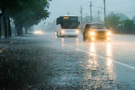
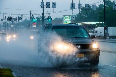
An "upper-level disturbance" is moving across the region today and will generate some showers and thunderstorms, some of which will include slow-moving downpours.

Since there will be the risk for multiple slow-moving downpours over the same area ("training storms"), there will be an increased risk for localized flash flooding.

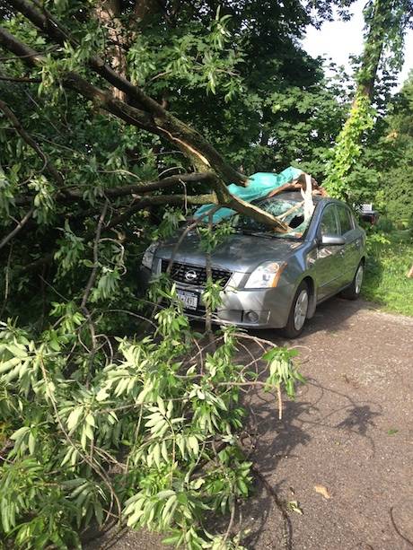
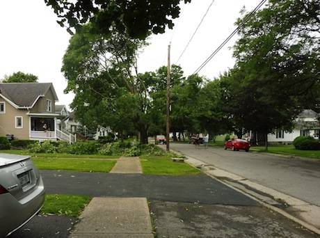
By Thursday, a slow-moving cold front will cross Western New York and numerous showers and thunderstorms will occur along and ahead of this cold front, which will likely produce significant rain.

Severe thunderstorm warning issued for Southwest Genesee County

By Howard B. Owens

A severe thunderstorm warning has been issued for the southwest part of Genesee County until 6 p.m.

The storm is capable of producing quarter-sized hail and winds in excess of 60 mph.

The storm is moving northeast at about 30 mph.

Rainy weather has also forced the Batavia Muckdogs to postpone tonight's came at Dwyer Stadium. The game will be made up as part of a doubleheader Tuesday.

UPDATE: A flash-flood warning has been issued for eastern Genesee County, including Batavia. Already as much as of two inches of rain has fallen, according to the National Weather Service. Heavy rain is expected to continue. The warning is in effect until 9 p.m.

Weather outlook is hazardous, with showers, thundershowers and strong winds possible this week

By Billie Owens

A hazardous weather outlook was issued this afternoon by the National Weather Serivce in Buffalo for Western and North Central New York.

It says that starting Monday, a cold front will cross the region and showers and thundershowers will be likely along and ahead of the front, with a few of these becoming strong to severe with strong to damaging wind gusts.

Hazardous weather outlook in effect, plus flash-flood watch issued

By Billie Owens

The National Weather Service in Buffalo reports that a moisture-laden, tropical-like airmass will remain in place across Western New York through this evening. A flash flood watch and a hazardous weather outlook are in effect.

This sultry airmass will be favorable for thunderstorms with heavy rain to develop across Western New York, especially late this afternoon and evening when a cold front will bear down on the region from Southern Ontario, Canada.

Since many areas have already been primed with heavy rains from the past several days, additional torrential downpours will worsen an already elevated risk for localized flash flooding.

The combination of oppressive heat and very humid air will produce apparent temperatures in the mid- to upper 90s across a large percentage of the region. These values will approach heat advisory levels and then the chances for heat-related illnesses will increase for those doing outdoor activities.

Immediate, severe thunderstorm warning issued for Genesee County

By Howard B. Owens

A severe thunderstorm warning has been issued for the northern half of Genesee County, including Pembroke, Batavia and Le Roy, starting immediately.

The National Weather Service has spotted a storm on doppler radar moving into the area that is capable of producing 60 mph winds. It's moving northeast at 55 mph.

Early morning thunderstorms cause power outages and damages

By Traci Turner

Trees and power lines are down due to a line of thunderstorms that swept through Genesee County early this morning.

As of 9 a.m., National Grid has reported hundreds of customers affected from the power outages in Le Roy, Pavilion and Attica. There are also scattered outages in other areas affecting less than 10 customers each.

Law enforcement advises motorists to use caution because debris could still be blocking some roads.

img_0515.jpg

(Storm damage on North Street in Le Roy. Photo taken by Lucie Griffis.)

p1020604.jpg

Gilbert Street at the corner of West Main Street in Le Roy is closed due to power lines down across the street. According to Tom Wood, 2nd assistant chief for Le Roy Fire Department, three power lines are down. Residents are waiting for National Grid crews to restore their power.

p1020606.jpg

Pictured below a tree down on South Jackson Street, Batavia.

6-23-15_mg_7140.jpg

Severe thunderstorm warning issued, includes southwestern GC

By Billie Owens

A severe thunderstorm warning was issued by the National Weather Service Office in Buffalo at 3:14 p.m. and remains in effect until 4:15 p.m. It includes southwestern Genesee County and three other counties.

Doppler radar indicated a line of severe thunderstorms capable of producing quarter-size hail and damaging winds in excess of 60 mph. These storms were located along a line extending from six miles southwest of Niagara Falls to 13 miles northwest of Angola on the Lake, moving east at 45 mph.

Be prepared for damaging winds, destructive hail, deadly lightning and very heavy rain.

Meanhwile, a severe thunderstorm watch remains in effect until 10 p.m.

Strong thunderstorm reportedly heading toward Genesee County

By Howard B. Owens

A severe thunderstorm warning is in effect until 11:30 a.m.

The storm reportedly is capable of producing damaging winds in excess of 60 mph. At the time of the warning, the storm was 10 miles south of Hamburg and moving northeast at 50 mph.

UPDATE 10:38 a.m.: A tornado warning has been issued for portions of Wyoming County, including Warsaw.

Hazardous weather outlook in effect, plus flash-flood warning issued

By Billie Owens

There's a harzardous weather outlook in effect for Western New York, according to the National Weather Service in Buffalo. A slow-moving cold front will drop southeastward across the Eastern Great Lakes Region and it has the potential to produce a few strong thunderstorms with heavy rainfall.

In addition, a flash-flood warning has been issued for Southeastern Genesee County and Central Wyoming County until 8:45 p.m.

At 5:46 p.m., Emergency Management reported thunderstorms producing heavy rain across central Wyoming County, and specifically Pavilion in Genesee County. Those in affected areas are advised to move to higher ground now.

Photo: Tree damaged in evening storm in Alexander

By Howard B. Owens

alexandertreedownmay272105.jpg

Alexander resident Liz Farmer shared this photo of a tree that was damaged by the storm that passed through the area about 7:30 p.m. She said the strong winds and heavy rain had some trees blowing sideways. This tree damaged the roof of her shed.

Send storm damage photos to howad@thebatavian.com.

Weather service warns of severe thunderstorm heading through Genesee County

By Howard B. Owens

A severe thunderstorm warning has been issued for our area through 10:45 p.m.

A storm is heading our way from Erie County at 45 mph, according to the National Weather Services.

The storm is capable of producing winds up to 60 mph. Torrential rainfall is occurring within this storm and may lead to flash floods.

Weather service warns conditions today increase risk from fire

By Howard B. Owens

A red flag warning has been issued for Western New York as the National Weather Service anticipates low humidity and strong winds from noon today until 7 p.m.

A red flag warning is issued when conditions appear ripe for fires to get out of control quickly.

Temperatures are expected in the low 70s with winds of 20 to 25 mph.

Photos: Batavia hit with a bit of spring snow and cold

By Howard B. Owens

Austin Park is a long way from Florida, especially when just two weeks ago, when Cheri Pitcher was there, it was 90 degrees.

"I was surprised how cold it was this morning," Pitcher said while braving the cold and dusting of snow to take her dog for a walk.

It was 28 degrees this morning.

Severe thunderstorm warning issued for Western Genesee County

By Billie Owens

The National Weather Service is Buffalo has issued a severe thunderstorm warning for Western Genesee County until 5 p.m.

The thunderstorm is said to be capable of producing damaging winds in excess of 60 mph. The storm was located near Alden and is moving northeast at 50 mph. Oakfield is specifically mentioned in the warning.

Photo: Windmills working hard as wind picks up

By Howard B. Owens

By early this evening, the wind was whipping enough to really turn the blades on the windmills on Partridge Farms on Ellicott Street Road, Batavia.

There is a weather advisory in place until 9 p.m. There's a 90-percent chance of rain storms after 9 p.m.

The good news is, clear skies tomorrow, or so they say.

Wind advisory issued for this afternoon

By Howard B. Owens

A wind advisory has been issued for this afternoon with winds of 15 to 25 mph expected from 2 p.m. into late evening.

Gusts of up to 50 mph are possible.

The winds will be from the southwest.

The weather service warns of tree branches down and isolated power outages. Travel may be difficult for high profile vehicles. Unsecured items should be brought indoors.

Wind damage hitting Genesee County

By Howard B. Owens

A vent on the roof of Ken's Charcoal Pits/City Slickers blew off the roof a short time ago. Owner Ken Mistler said the trees seemed to have saved three cars that were parked on the street from damage.

The restaurants remain open.

Meanwhile, a reader sent in the bottom picture of a downed tree at the Blind School and Bethany fire has been dispatched to 9524 Clipnock Road for a report of a utility pole that has broken and only being held up by wires.

There's also report of a tree down with wires involved at 240 State St., near Hart Street, Batavia, and wires "ripped from the residence" on Pearl Street Road. City fire is responding to the first call, East Pembroke to the second.

UPDATE 2:48 p.m.: A tree fell onto a car at 161 Washington Ave. in the city and wires are also down. City fire responding.

UPDATE 2:56 p.m.: A tree and wires are down across the roadway, blocking traffic, at 259 Ross St. and city fire is responding.

UPDATE: more photos ... 

State Street

Centennial Park

Washington Avenue

UPDATE: Ross Street

UPDATE, photo from Greg Rada of Clipnock Road.

High wind warning issued for tomorrow

By Howard B. Owens

High winds are expected to blow into Genesee County tomorrow morning with the potential to bring down trees and power lines.

A high wind warning is in effect from 8 a.m. to midnight Friday.

Winds of 25 to 35 mph with gusts up to 60 mph are expected.

Authentically Local