
weather

Difficult travel conditions reported in Alabama

By Howard B. Owens

Authorities in Alabama are requesting a travel advisory because of near zero visibility. 

Alabama fire is on scene of a single-car accident at Route 63 and Route 77 with wires down. A wire is on a vehicle.  No injuries are reported.

Traffic is being closed at Ledge Road and 77.

It sounds like there are other property damage accidents in the area.

There is an accident, perhaps Route 63 and 77, with seven people in the vehicle. No injuries.

Mercy EMS is responding to Route 63 and 77 because of the wire on the car.

Traffic is being closed at Phelps Road by Pembroke fire.

UPDATE 1:18 p.m.: Traffic is being slowed at Kearns Road, Pembroke.

UPDATE 1:18 p.m.: A car has struck a pole at Marble Road, wires down.  

UPDATE 1:29 p.m.: National Grid is on location.

Forecast is for heaviest snowfall in the morning

By Howard B. Owens

From 13WHAM's weatherman Marty Snyder:

Lake effect snow has been falling through Wyoming County this morning. That band will gradually lift north into Genesee County by the late afternoon. It will first line up through the southern towns of Genesee County. Throughout the evening, the band will continue to move northward to along the Thruway, and closer to Batavia. By tomorrow morning, there is the potential of 6 inches of snow in the heaviest portions in the lake effect band, then another 6 inches of snow later in the day. It is very important to note that many parts of Genesee County will see much less snow than this maximum amount, since they will remain outside the focus of the most intense snow.

A lake effect snow warning will remain in effect from noon today through 10 a.m. on Friday for Genesee County.

13WHAM is The Batavian's news partner.

Lake effect snow warning issued for Genesee County

By Howard B. Owens

We're now looking at a lake effect snow warning for this afternoon through 10 a.m. Friday.

This covers all of Genesee County. 

Some 10 to 18 inches of snow are possible. 

Winds will be from the southwest at 20 to 30 mph with visibility dropping to a quarter of a mile at times.

Blowing and drifting snow will result in hazardous travel conditions, the National Weather Service warns.

If traveling, conditions can change quickly.

UPDATE: Officials say plans for tonight's centennial celebration will go ahead as scheduled.

Lake effect snow watch issued for Wednesday and Thursday

By Howard B. Owens

There is a lake effect snow watch in effect from late Wednesday afternoon through Thursday night.

Potential accumulation of six to 12 inches.

Winds from the southwest of 20 to 30 mph.

Wind chill down to zero.

Visibility as low as a quarter of a mile at times. 

Blowing and driving snow and wind could make travel difficult.

"There remains some uncertainty with the exact placement and intensity of the lake effect snow bands," said the weather service.

Lake effect snow predicted for Batavia

By Howard B. Owens

The National Weather Service is reporting that Doppler radar indicates an area of lake effect snow is heading for Genesee County, and Batavia and northern parts of the county specifically.

The storm is reportedly capable of producing up to a half-inch of snowfall an hour.

Visibility will be reduced to a half mile during the storm.

The storm will spread east through 11:30 a.m.

Photo: Wind-damaged silo in Elba

By Howard B. Owens

A reader sent in this picture of a wind-toppled silo on his property on Transit Road, Elba. He said it came down overnight.

High-wind watch in place for Christmas Eve, Christmas Day

By Howard B. Owens

It looks like we won't have a white Christmas, but we will have a windy one.

The National Weather Service has a high wind warning in place from 8 p.m., Wednesday until 4 p.m., Thursday.

Winds from the southwest of 30 to 40 mph with gusts up to 65 mph are anticipated.

Impacts could include downed trees and power lines and scattered power outages. 

High profile vehicles will find travel difficult. 

Holiday decorations could be damaged if not tied down. 

No word from Santa on his travel plans.

Genesee County included in FEMA disaster designation for November storm

By Howard B. Owens

Press release:

Today, senators Charles E. Schumer and Kirsten Gillibrand and representatives Brian Higgins, Chris Collins, and Tom Reed announced that the Federal Emergency Management Administration (FEMA) has approved a federal disaster designation for nine Western New York counties, due to losses caused by excessive snow, flooding, freeze, and high winds that occurred from Nov. 19-26.

The FEMA disaster declaration will apply for the following counties: Cattaraugus, Chautauqua, Erie, Genesee, Jefferson, Lewis, Orleans, St. Lawrence, and Wyoming. This declaration will officially make municipalities within in these nine counties eligible for public assistance, which provides federal funds for emergency work and the repair or replacement of disaster-damaged facilities. These nine counties were deemed eligible for FEMA public assistance funds because they reached the specific damage threshold.

With this declaration, the state, counties, local governments, and certain nonprofit organizations will be eligible to apply for funding for debris removal, emergency protective measures, and permanent work, including the repair and replacement of disaster-damaged facilities. Specifically, permanent work can include the repair of roads and bridges, water control facilities, and utility systems and facilities; the repair or replacement of buildings and equipment; and the repair and restoration of parks, recreational facilities, and other facilities. In November, following the storm, Schumer, Gillibrand, Higgins, and Collins wrote to FEMA and urged the agency to be ready to issue this declaration so that emergency assistance could be made available to the municipalities in the counties that suffered as a result of this historic November snowstorm.

“This much-deserved federal disaster aid is just what the doctor ordered for hard hit taxpayers and county, city and town governments throughout Western New York, which had to spend heavily to dig out from this epic snowfall. We fought hard to deliver this federal aid and are pleased FEMA and the Obama Adminstration did the right thing so local taxpayers are not left footing the bill for this national disaster,” said Senator Schumer, who called FEMA Administrator and top White House officials to lobby for a prompt decision. “With this designation, Cattaraugus, Chautauqua, Erie, Genesee, Jefferson, Lewis, Orleans, St. Lawrence, and Wyoming counties will receive the support they need to recover and rebuild after this severe weather.”

"This federal disaster declaration is outstanding news for Western New Yorkers, and I thank President Obama for moving fast to make this decision,” Senator Gillibrand said. “I saw firsthand how devastating the unprecedented snowstorm was to our communities. I want to thank everyone for their effort as it was essential for losses to be documented efficiently and thoroughly so that we could quickly demonstrate to FEMA our need for these federal recovery funds. The state and the nation can all be inspired by the toughness and optimism of Western New York.”

“I applaud the President’s decision to issue a disaster declaration for the State of New York,” Congressman Higgins said. “This declaration will trigger federal funds from FEMA, providing critical support to eligible entities in nine counties, to help in recovery from the recent snowstorm, and assist in protecting against damage from future natural disasters.”

“The President’s disaster declaration today is an important step in aiding the rebuilding process for the thousands of individuals and businesses impacted by the deadly November storm,” said Congressman Chris Collins (NY-27). “I am proud of our first responders who worked tirelessly during the storm and our local officials who spent the last month assessing the damage.”

“I am glad that we were able to work together on a bipartisan basis to secure this support from FEMA and the President. This declaration is fair to the affected communities to help move forward from the major snowstorm in November,” Congressman Tom Reed said.

On November 19, New York declared a state of emergency for 10 counties in advance of the severe snowstorm which ended up causing nearly $50 million in damage to Western New York and the North Country. Areas in South Buffalo and the surrounding communities received a historic seven feet of snow. The storm caused damage to many businesses’ and residents’ property, including some roofs that caved in under the weight of the snow. This damage is all in addition to the economic injury that many small businesses suffered after being closed for a week.

FEMA public assistance funding covers 75 percent of the eligible cost for emergency measures and permanent restoration. All areas in New York are also eligible to apply for funding under the Hazard Mitigation Grant Program, which provides grants to states and local governments to implement long-term hazard mitigation measures.

Winter weather advisory in effect until 7 tonight

By Billie Owens

A winter weather advisory has been issued by the National Weather Service in Buffalo and it's in effect until 7 p.m.

Expect patchy, freezing drizzle mixed with light snow at times. This will create slick spots on untreated surfaces. Slight ice accumulation is also expected, with temperatures in the low 30s.

Residents clear paths through the snow after storm passes

By Howard B. Owens

Somewhere in the neighborhood of a foot of snow fell on Batavia overnight and this morning residents were clearing driveways and sidewalks.

From 13WHAM, The Batavian's news partner, here's a forecast:

Most of the steady snow has now moved west and out of the area. The chance of some scattered snow showers will remain through the day, but not the steady type of snow that we have already experienced. Another inch of snow could fall from any of the snow showers that pass through the rest of today. A Winter Weather Advisory does remains in effect for Genesee and Wyoming counties through 4 a.m. tomorrow. As of earlier this morning, 10 inches of snow had fallen in Warsaw, 4.5 inches in Avon, 6.5 inches near Silver Springs, 10.4 in Wyoming, and 5.5 inches near Dansville.

It will take a while for any melting to begin. Temperatures will remain in the 20s for much of today. Temperatures will rise to about the freezing point for a high tomorrow, but will rise higher, into the 30s and 40s, by this upcoming weekend and early next week.

Top photo: William Palone on East Avenue at Ross Street.

Marilyn Canipe on North Spruce Street.

A bike rider trying to negotiate his way through the snow and slush on North Street.

Weather closures for Thursday

By Howard B. Owens
  • Due to the snow, the City of Batavia Yard Waste Station is closed today. It will be open Friday and Saturday. The Yard Waste Station will be closed for the season at 5 p.m. on Saturday.

Send closures and cancellations, if any, to howard@thebatavian.com

Genesee County covered in storm disaster area designation by USDA

By Howard B. Owens

Press release:

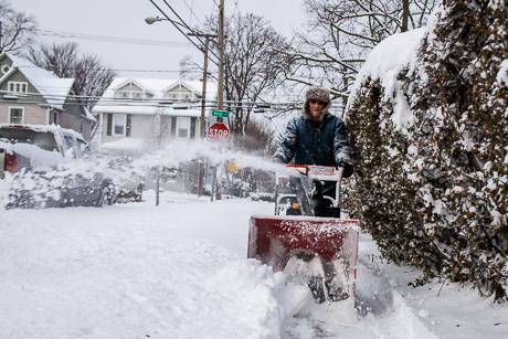
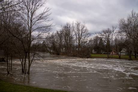
Today, senators Charles E. Schumer and Kirsten Gillibrand and representatives Brian Higgins and Chris Collins announced that the U.S. Department of Agriculture has approved primary and contiguous disaster designations for seven Western New York counties, due to losses caused by excessive snow, flooding, freeze, and high winds that occurred Nov. 17-24. The Secretarial natural disaster declaration will apply for the following counties: Genesee, Erie, Livingston, Monroe, Niagara, Orleans and Wyoming.

Last month, following the storm, Schumer, Gillibrand, Higgins and Collins urged the USDA to assess damage and be ready to issue this declaration so that emergency loans could be made available to the farmers, flower growers, and local producers that suffered as a result of the historic November snowstorm. The lawmakers said that USDA assistance is available to farmers who experience severe crop, livestock and business loss.

“After weathering several days of brutal weather and record-high snowfall, the USDA’s decision to provide emergency disaster assistance to farmers and growers across seven Western New York counties is welcome news. I visited many communities and saw the damage the snow caused firsthand. Thankfully, this disaster declaration means our Upstate farmers and growers will have access to critical emergency loans and more, at a time when they need it the most,” Senator Schumer said. “I applaud the U.S. Department of Agriculture for swiftly assessing the damage to farms, flower growers, vineyards, wineries and orchards throughout the region following the historic snowfall in November, and coming through with disaster designation.”

Senator Gillibrand, the first New York senator to serve on the Senate Agriculture Committee in nearly 40 years, said:

"I saw firsthand the severe losses Western New York’s agriculture community faced after last month’s unprecedented snowfall. The stories I heard were powerful. This declaration will enable those who lost greenhouses, barns, processing facilities, harvesting equipment, animals, trees, vines and crops to access resources that will help them as they recover and begin planning for a new growing season. I thank Secretary Vilsack and the dedicated staff of the Farm Service Agency who worked so hard to make sure the voices of our farmers were heard and that this much-needed aid is being made available."

Congressman Higgins: “Farm communities in Western New York were hit hard by the November snowstorm, and the federal government has an obligation to respond. This disaster caused loss of crops and business impacting the livelihood of local farmers. We applaud the USDA’s willingness to provide much needed relief to those struggling to recover from damages caused by the storm.”  

Congressman Chris Collins (NY-27): “Western New York's agriculture community took a huge hit during the historic November snowstorm and our local farmers and growers need help. I am pleased that our bipartisan push worked and the USDA is taking action necessary to provide needed disaster assistance.”

The senators and congressmen explained that this Secretarial disaster designation will make farm operators eligible to be considered for Farm Service Agency (FSA) emergency loans. Farmers in the eligible counties will have eight months from the date of the Secretarial disaster declaration to apply for such emergency loans.

The programs available with a USDA disaster declaration are as follows:

·         Emergency Farm Loans -- low interest loans;

·         Disaster Set-Aside Program -- borrowers located in designated disaster areas or contiguous counties who are unable to make their scheduled payment on any FSA debt can set aside one payment after a disaster.

Additionally, the following programs are available through the USDA without a disaster declaration:

·         Tree Assistance Program (TAP) -- provides financial assistance to qualifying orchardists and nursery tree growers to replant or rehabilitate eligible trees, bushes and vines damaged by natural disasters;

·         Livestock Indemnity Program (LIP) -- provides benefits to livestock producers for livestock deaths in excess of normal mortality caused by adverse weather;

·         Forest Restoration Program (FRP) -- helps the owners of non-industrial private forests restore forest health damaged by natural disasters;

·        Emergency Assistance for Livestock, Honey Bees, & Farm-raised Fish (ELAP) -- provides emergency relief to producers of livestock, honey bees, and farm-raised fish from other natural disasters that are not adequately covered by any other disaster program.

In their letter to Secretary Vilsack last month, Schumer, Gillibrand, Collins and Higgins wrote: “We urge USDA to dedicate all available resources to complete a damage survey in the most timely manner to assess the need for a USDA disaster declaration to prevent the delay of any needed emergency relief. Additionally, we request that FSA field officers work with farmers to help them accurately document losses, which will enable them to apply for USDA disaster programs.”

Photo: Snowfall arrives during evening commute

By Howard B. Owens

The predicted snowfall for this morning didn't really materialize, but it's coming down pretty good right now, with a prediction of up to two inches by 7 p.m.

Here's 60 seconds of what it was looking like at Main and Center a few minutes ago:

Heavy snow predicted for Wednesday into Thursday

By Howard B. Owens

A winter storm warning for heavy snow has been issued for 4 a.m. through 6 p.m., Thursday, replacing the previous storm advisory.

Precipitation will start start tonight and change over to snowfall by the morning.

A storm total of 8 to 14 inches is predicted, with 3 to 5 inches in the morning and 4 to 6 inches Wednesday night and 1 to 3 inches Thursday.

Winds from the northwest at 10 to 20 mph.

Visibility will be reduced to a quarter of a mile at times.

Predicted winter storm downgraded

By Howard B. Owens

A winter weather advisory has been issued by the National Weather Service for 1 a.m. Wednesday through 4 a.m. Friday, with a storm total of 7 to 13 inches of snow.

The winter weather watch is cancelled.

The storm could bring 2 to 4 inches of snow Wednesday, 1 to 3 Wednesday night, 2 to 4 inches Thursday and up to 2 inches Thursday night.

The greatest snowfall is expected across higher terrain and south of the Thruway.

Winds will be from the northwest at 15 to 25 mph.

Visibility could drop to a half mile at times.

Weather forecast for the next few days

By Howard B. Owens

From Kaylee Wednt, meteorologist at The Batavian's news partner, 13WHAM:

We expect Tuesday to be mainly gray, but some breaks of limited sunshine are possible. The temperature may reach 40 degrees through the course of the day keeping any precipitation that we may see in the form of rain. A winter storm watch is in effect from 7 p.m. Tuesday through 7 a.m. Thursday. A storm system will drift north from New Jersey into New England. Snow from this system will be enhanced over Lake Ontario producing snow accumulation through Thursday morning. Tuesday night an inch or less of snowfall will accumulate on the ground. We feel that the greatest chance for any substantial accumulation will take place on Wednesday. The snow intensity may briefly increase through the afternoon. We expect to see 3-6” of snowfall throughout the course of the day. A north/northwesterly flow lake enhancement is likely, especially north of the Thruway. This may bring another 1-3” to the area Wednesday night and Thursday morning. Many areas will see storm totals between 6 and 12”. Check back for further updates on this storm system from the 13WHAM Weather Authority.

Winter storm watch issued for Tuesday evening through Thursday morning

By Howard B. Owens

From 6 to 12 inches of snow may fall on the area some time between Tuesday evening and Thursday morning, according to the National Weather Service.

Winds of 10 to 20 mph from the northwest are expected and visibility during the heavy parts of the storm are expected to drop to a half mile.

A winter storm watch is in effect.

The weather service warns of slick roads and difficult travel.

The forecast confidence is "medium."

The Tonawanda Creek reaches minor flood stage

By Howard B. Owens

The Tonawanda Creek has reached a minor flood stage of nine feet high and is expected to crest this afternoon at 9.3 feet, according to the National Weather Service.

Photo from about an hour ago at the spillway behind the County Courthouse.

More photos of spectacular rainbows in Genesee County today

By Howard B. Owens

From Kate Parmenter at Town of Batavia Town Hall.

From James Renfew in Bergen Byron.

From Brandi Bruggman in Batavia.

From a reader who didn't provide any other information.

UPDATE: A photo from Kati Nichole in Pavilion.

Authentically Local