
weather

Severe thunderstorm predicted for area this afternoon

By Howard B. Owens

"There is even a low chance for a tornado," concludes a National Weather Service statement establishing a severe thunderstorm watch for Ohio, Pennsylvania and Western New York.

"The strongest storms may form into a line and quickly move east along the New York and Pennsylvania border affecting the western Southern Tier and upper Genesee Valley," according to the weather service.

Strong winds, heavy rain and small hail are expected.

All of Genesee County is under the watch. It's in effect until 8 p.m.

Severe thunderstorm watch in effect until 10 p.m.

By Billie Owens

A severe thunderstorm watch has been issued by the National Weather Service's Storm Prediction Center in Norman, Okla., and is in effect now through 10 p.m.

UPDATE 6:30 p.m.: The watch has been cancelled.

Kids seek cool of Spray Park on day of first heat advisory of the summer

By Howard B. Owens

Kasandra Sturgeon plays with her sister Hannah at the Spray Park in Austin Park today. It was Hannah's first trip there.

Dozens of kids were out this afternoon on what may be the hottest day of the year so far. The National Weather Service has issued a heat advisory, warning of an increased possibility of heat-related illness on a day with temperatures into the 90s and high humidity.

Stay cool and stay hydrated.

Severe thunderstorm warning issued

By Billie Owens

A severe thunderstorm warning has been issued for western Genesee County and it remains in effect until 9 p.m.

A few minutes ago, Doppler radar indicated a line of severe thunderstorms capable of producing quarter-size hail and damaging winds in excess of 60 mph.

These storms were moving 45 mph in a northeasterly direction.

Le Roy calls all manpower to fire hall due to flooding problems in the area

By Billie Owens

All available manpower is called to Le Roy's fire hall to with help local flooding issues. The underpass of Route 5 is completely unpassable. A flash flood watch is in effect throughout the county this evening.

UPDATE 6:52 p.m.: Fire Police are requested to Gilbert Street and Route 5.

UPDATE 7:08 p.m.: Power lines down from a residence on Church Street, Le Roy.  No arcing or sparking at this time.

UPDATE 7:11 p.m.: Bergen requested to stand by in its hall for flooding.

UPDATE 7:17 p.m.: Pavilion requested to stand by in Le Roy's hall.

Flash flood watch issued for this afternoon and evening

By Howard B. Owens

A flash flood watch has been issued for Genesee County through this evening.

During the afternoon, showers and thunderstorms will develop, according to the National Weather Service, in a warm and humid airmass. These storms will have the potential to produce torrential downpours, with rates of one to two inches per hour.

Storm-related calls for this evening

By Howard B. Owens

A tree and wires are down at 5968 W. Sweden Road, Bergen. The roadway is blocked. Bergen fire dispatched.

A tree and wires are down at 45 Church St., Elba. Elba fire dispatched.

UPDATE 8:35 p.m.: A utility pole has snapped and power lines are down in the area of 6112 Byron Elba Road. Byron and South Byron fire departments dispatched.

UPDATE 8:43 p.m.: A tree and wires are down in the area of 1075 Ham Road, Alabama. Alabama fire dispatched. Also, on 6323 Warboys Road, a pole is down with wires in intact.

UPDATE 9:43 p.m.: Town of Batavia Fire Department is requested to 5025 Ellicott Street Road, Batavia, for water coming through an electrical panel.

UPDATE 10:02 p.m.: State Police have requested Pavilion fire police to shut down Route 63 at Route 19 because of a stuck railroad crossing gate.

Person trapped in vehicle filling with water gets out

By Billie Owens

A person who was trapped inside a flooding vehicle at 1600 Erie St. in Darien managed to get out. Darien firefighters are on scene. The location is between Tinkham and Alleghany roads.

UPDATE 8:54 p.m.: Darien fire is back in service.

Flash flood warning issued by weather service

By Billie Owens

From the National Weather Service in Buffalo:

A flash flood warning has been issued for Southwestern Genesee County until 12:45 a.m., June 13, by the National Weather Service.

At 8:20 p.m. the Doppler radar indicated a narrow band of torrential rainfall from a persistent area of thunderstorms. Radar estimates that two to three inches of rain has has fallen in a small area, including the towns of Darien and Alexander. An additional one to two inches are possible through late evening.

Excessive runoff from heavy rainfall will cause flooding of small creeks and streams, country roads, as well as farmlands along the banks and creeks.

Never drive through flooded roads, or turn around. Don't drown!

Hazardous weather outlook through Friday with showers, thunderstorms, possibly heavy rain

By Billie Owens

A hazardous weather outlook has been issued for Western and North Central New York by the National Weather Service.

A warm front will move across the region today and it will generate some showers and thunderstorms, which could include some heavy rain. The highest chance for heavy rain will be close to Lake Ontario.

A warm and humid air mass Thursday and Friday will support more showers and thunderstorms. There will be a chance locally for heavy rainfall.

Hazardous weather outlook - showers, thunderstorms expected today

By Billie Owens

A hazardous weather outlook has been issued by the National Weather Service in Buffalo.

Low pressure is expected to track across portions of Western New York this afternoon and evening, bringing showers and thunderstorms, and possibly some localized flooding.

The likelihood of widespread hazardous weather is low.

What's with the Weather?

By Leslie DeLooze

Richmond Memorial Library, 19 Ross St., Batavia presents “What’s with the Weather?,” a talk for adults on Monday, July 7 at 7:00 p.m.  Jon Hitchcock, a senior forecaster with the National Weather Service, will talk about weather patterns in Western New York that bring the more interesting weather to our region.  Registration is not required for this free program. More information is available in the library and at www.batavialibrary.org

Event Date and Time
-

Severe thunderstorm warning for northwestern Genesee County

By Billie Owens

The National Weather Service in Buffalo has issued a severe thunderstorm warning for northwestern Genesee County along with other portions of Western New York until 6:45 p.m.

The Weather Service's Doppler radar has indicated a severe thunderstorm capable of producing quarter-size hail and damaging winds in excess of 60 mph.

This storm was located near Akron, or 11 south of Medina, and it's moving northeast at 15 mph.

This is a dangerous storm. If you are in its path, prepare immediately for damaging winds, destructive hail and deadly cloud-to-ground lightning. People outside should move to a shelter, preferably inside a strong building but away from windows.

Flash flood watch in effect this afternoon through Friday afternoon

By Billie Owens

A flash flood watch is in effect from 2 p.m. today through Friday afternoon. According to the National Weather Service, this includes portions of Western New York, including Genesee County and the City of Batavia.

The Weather Service says showers and thunderstorms are forecast to develop in a warm and humid airmass this afternoon and tonight. These storms will be capable of producing localized downpours with rainfall rates of 1 to 1.5 inches per hour. As a slow moving cold front approaches from the west, the showers and thunderstorms will become more widespread Thursday afternoon and night.

A flash flood means the threat of flash flooding exists along rivers and creeks. If you are in the watch area, you should monitor weather conditions closely. Be ready to move to higher ground if flooding is observed or a warning is issued.

Weather Service issues severe thunderstorm warning

By Billie Owens

A severe thunderstorm warning has just been issued for Genesee County by the National Weather Service in Buffalo. It is in effect until 6:15 p.m.

At 5:21 p.m., the Doppler radar indicated a line of severe thunderstorms capable of producing damaging winds in excess of 60 mph.

These storms were located along a line extending from eight miles west of Waterport to Arcade, and moving east at 50 mph. Strong winds are pushing out ahead of this line and winds will begin prior to any rain or lightning.

Some locations in the warning include Batavia, Pavilion and Le Roy.

Wind damage with these storms will occur well ahead of any rain or lightning. Don't wait for the sound of thunder before taking cover. Seek shelter immediately inside a sturdy structure and stay away from windows.

Frost advisory issued for the early morning hours

By Howard B. Owens

There is a frost advisory in effect overnight with temperatures expected to fall into the mid 30s.

The advisory is from 2 to 8 a.m.

An overnight frost could damage tender spring vegetation and outdoor potted plants. The National Weather Service recommends taking steps to protect plants.

Wind advisory issued for Tuesday

By Howard B. Owens

Strong winds are expected to hit Genesee County tomorrow, so the National Weather Service has issued a wind advisory for 8 a.m. through 5 p.m.

Winds from the southeast of 25 to 35 mph are expected, with gusts up to 50 mph.

Farmers watching weather closely as seasonal planting window narrows

By Howard B. Owens

As it is every year, local farmers are playing the weather lottery. What numbers will come up, nobody knows.

In the meantime, they're planning their crops, waiting for a little dry spell and a bit warmer weather to start planting.

"We always hope every single year that Mother Nature will give us a good growing year," said Barbie Starowitz, of Star Growers Farm in Elba. "We think that every year. We hope every year for a good year just to pay the bills."

For many crops, now is the ideal time for getting seeds in the ground, but when the soil is still too soft from rain or the temperature still a bit cold (as it's expected to be for the next few nights), then farmers may run out of time to sow all their fields, if any.

CY Farms has started planting onions -- as have other farmers -- because, as CEO Craig Yunker says, "the muck is more forgiving," but his crews still haven't started on peas or corn.

Yunker said they like to start planting around April 1 and corn seed should start going in the ground by April 20. So far, CY has yet to plant a single acre of corn or peas.

"We'd like to get going," Yunker said.

This year, CY Farms will return to growing cabbage. The Yunkers made headlines last year when they decided to forgo cabbage.

Craig Yunker cited three reason for cutting the crop: The uncertainty raised by the employer mandate in Obamacare; the loss of labor to an immigration audit; and the high price of corn.

This year, the employer mandate is delayed for at least a year (allowing CY Farms to employ more than 50 people); Yunker has been able to find some qualified help to replace the workers he lost; and corn has dropped nearly $2 in price per bushel and is now trading at just under $5.

Those three factors led Yunker and his managers to decide to cut corn acreage this year and grow cabbage again.

For Star Growers, the crop mix will be pretty much the same as always -- corn, peas, soybeans, wheat, cabbage and onions.

Most of what Star grows goes to canning factories, either Seneca or Bonduelle.

"We've been waiting for a good growing season, but Mother Nature seems pissed at us," Starowitz said. "It's either too wet or too dry."

Like Star Growers, MY-T Acres grows mainly for canners and food processors. Pete Call said this year's crop will be pretty much like the last few years: green beans, peas, cabbage, potatoes for potato chips, spinach, sweet corn, red beets, grain corn, wheat, rye, oats and alfalfa.

We couldn't reach Torrey Farms, another large crop farm in the county, for comment.

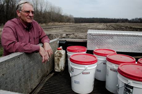
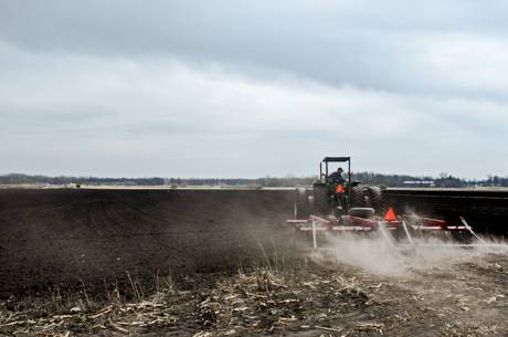
Top Photo: Craig Yunker, CY Farms, with buckets of onion seeds. Each bucket holds 500,000 seeds and costs the farm $1,410. "It's the most expensive seed we buy," Yunker said. Below, preparing the muck to be seeded.

Authentically Local