Tornado watch in effect from now until 10 p.m.
The National Weather Service has issued a Tornado Watch for today until 10 p.m.
The watch covers all of Western New York.

The National Weather Service has issued a Tornado Watch for today until 10 p.m.
The watch covers all of Western New York.
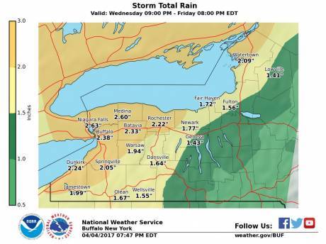
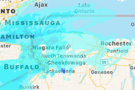
If the sun comes out over the next few hours, it could help energize a storm heading toward Western New York, according to the National Weather Service, which issued a special weather statement this morning.
The storm is likely to hit western counties between 3 and 6 p.m. and move east.
Cloud cover this morning could limit the storm's growth as a cold front pushes across the state.
A severe thunderstorm could include dangerously strong winds.
The slow-moving storm could also deliver downpours on top of already wet conditions raising concerns for flooding.
A flood warning for now through midnight has been issued for Genesee County.
There is already localized flooding reported on Rose Road, Batavia, Bloomingdale Road, Basom, Starr Road, Pavilion, and West Main in Le Roy.
As much as two inches of rain could fall on parts of Genesee County from the storm passing through the area.
There are seven power outages in the county, including a trio of outages in the city affecting about 200 National Grid customers between Bogue Avenue and Oak Street.
There are also small outages on Walnut Street and South Lyon Street and two in the Town of Alexander.
UPDATE 10:49 p.m.: Route 63 north of Transit Road and south of East Road in Bethany is being shut down due to flooding. There's also flooding reported on Route 20, but it appears to be passable so far.
UPDATE 12:02 a.m.: Route 63 is open. Bethany assignment back in service.
If you're in Batavia and think we're getting rain and thunder now, wait a bit. The National Weather Service says the storm is about to get stronger.
Winds in excess of 30 mph are possible as the storm moves through the area, with lightning and thunder. This storm cell is in Attica now and moving toward Batavia, Le Roy, and Pavilion.
Torrential rainfall accompanies this storm and may cause localized flooding.
Ground lightning strikes are possible.
Press release:
The City has completed its curbside collection of limbs and branches from the March 8 windstorm. Any resident with limbs and branches are encouraged to bring them to the Yard Waste Station on Law Street, Monday thru Saturday, noon to 6 p.m.
You thought you were done with winter? Expect snow tonight.
The National Weather Service has issued a winter weather advisory in effect from 11 p.m. to Friday, 2 p.m.
Expect wet snow, with snowfall coming heaviest from Lake Erie to about Batavia and lower amounts to the north and east.
Up to two inches could fall tonight with storm totals of three to five inches.
Winds will be 15 to 25 mph with gusts up to 40 mph, from the northwest.
Slick travel and low visibilities expected at times.
A flood watch remains in effect from Thursday morning through Saturday afternoon.
More than two inches of rain is predicted and the chance of rain Thursday and Friday is put at 100 percent.
The weather service said there is a chance of minor flooding. Those living in flood-prone areas should be prepared to take action.
A storm with heavy rain, 30 mph winds and rumbles of thunder is rolling into Batavia, according to the National Weather Service.
The storm has already come up through Darien, the weather service reports.
Gusts up to 50 mph are possible.
There's also a flood watch in effect from Thursday morning through Saturday.
It's time to batten down the hatches again. The National Weather Service has issued a wind advisory for Tuesday from noon until 11 p.m.
Winds from the west of 20 to 30 mph with gusts up to 50 mph are predicted.
Winds of this magnitude can cause tree limbs and power lines to come down causing localized power outages. Travel will be difficult for high-profile vehicles.
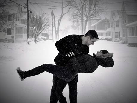
Here's a different take on a snowstorm picture. Matthew Bailey and Heather Lewis got engaged recently but hadn't yet gotten their engagement portraits taken, so today, in the midst of a snowstorm on Tracy Avenue, they thought it would be the perfect time to have their official engagement pictures taken. They will be married May 12. Bailey was recently hired as a corrections officer in the Genesee County Jail.
Photo submitted by Melissa Barone.
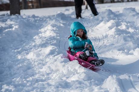
Lilah Guarino, 7, (top photo) and Quintin Hoca, 4, (below) couldn't wait to get to Centennial Park today to sled in the snow. The sun came out late this afternoon and they were there. It's the first time this winter there has really been enough snow for good sledding. Lilah's father said she's been bugging him all winter about sledding so she was eager to hit the slopes today.


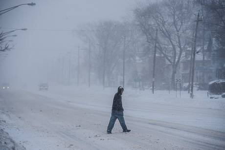
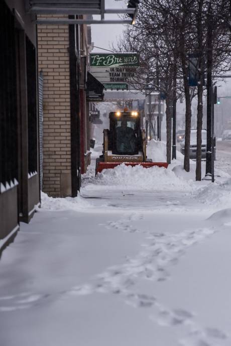
There's plenty of snow on the ground, it's cold and a winter storm warning remains in effect until 8 p.m., but the county's travel advisory has been lifted and conditions aren't too bad for a snowy, winter day.
Photo: 500 block of East Main Street, Batavia.
NOTE: The travel advisory has been lifted.
The Sheriff's Office has issued a travel advisory for Genesee County. Current and forecasted weather conditions consisting of steady and strong winds have caused whiteout conditions. These conditions are expected to continue for 24 hours. Motorists are strongly encouraged to avoid any unnecessary travel.
Cancellations and closures for Wednesday:
Send notifications to howard@thebatavian.com
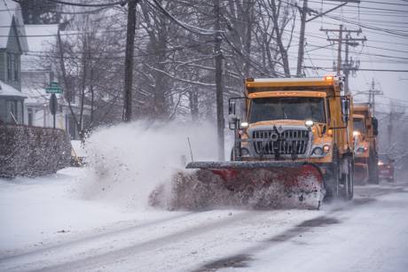
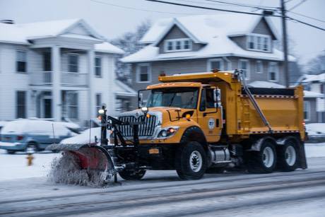
Crews were out and working in Batavia this morning dealing with the few inches of snow that fell overnight and this morning.
The winter storm warning remains in effect through 8 p.m. tomorrow with a prediction of steady snowfall and a storm total in the area of about 18 inches.
Gov. Andrew Cuomo has declared a statewide state of emergency starting at midnight.
We've received notifications of the following closing and cancellations:
Send closings to howard@thebatavian.com
There are going to be some unique features to the winter storm predicted to hit our county this evening and local officials are both preparing for unusual conditions and warning residents to prepare themselves.
First, there is the duration of the storm -- more than 48 hours of steady snowfall, about four inches every two hours. Second, there is the direction of the wind, coming from the north at the start of the storm rather than the usual west-southwest winds.
There is a winter storm watch in effect from tonight through 8 p.m. Wednesday with anticipated stiff winds and storm totals for snowfall of up to 20 inches in some parts of the county.
The winds won't be strong, but blowing in from the north changes the dynamic of the storm.
'It's going to be an almost three-day storm," said Tim Yaeger, emergency management coordinator. "I think highway crews are going to be able to keep up with it easily enough. The wind may cause a problem with visibility. Just the sheer temperatures will be difficult to deal with itself."
Yaeger said people need to be prepared for the idea that the storm will last for a while and travel conditions will naturally slow down emergency responses if there is a problem.
"The mantra that we always carry with emergency services is to be ready for 72 hours," Yaeger said. "Obviously, the past week proved that everyone needs to be prepared."
County Highway Superintendent Tim Hens said he's already reminded his crews that the wind is going to be coming from the north.
"The lake effect will enhance the snowfall rates for the nor'easter, but the odd thing is for the highway department is it affects roads different for us than we’re used to," Hens said. "Normally, we get west to southwest winds, so the north to south roads, you get a lot of blowing and drifting. We’ve had it before, so the guys are used to it, but it is a little bit different. You’ll have the east and west roads that are getting the whiteouts and the drifting."
Hens noted that snow fences along roadways are set up on north-south roads, not east-west, so blowing and drifting snow could be worse than a typical storm.
"Take a little time to think about where you’re going and realize that you’re going to get whiteouts on roads you don’t normally get whiteouts on," Hens said.
Sheriff William Sheron said drivers need to allow themselves enough time to get where they're going.
"Be prepared for slippery roads and whiteout conditions," Sheron said. "Reduce speeds and allow extra stopping distance."
Driver safety was also on the mind of Yaeger and Hens.
"If you don’t have to drive, delay that trip, delay that shopping trip if you can," Yaeger said. "Stay off the roads. Stay home. Stay safe. Stay warm."
It's been a light winter, Hens noted, so there hasn't been much demand on drivers this year to practice their snow-and-ice driving skills.
"People have probably gotten a little bit lazy in terms of winter driving skills, so just a reminder to give yourself extra time, give yourself a lot of room, respect the snowplows, try not to get up behind them too close and pass them," Hens said.
It's hard to say if we'll have power outages. The winds will not be that strong, but they are coming just days after a heavy windstorm that may have weakened some root systems or moorings for utility pools, but more importantly, the winds are coming from the north and tree root systems are set up to handle west-southwest winds.
Yaeger expressed a little concern, but Hens said he isn't anticipating an issue unless the winds come on stronger than expected.
"I think most of the trees are pretty good at handling 30 to 35 mph winds," Hens said. "It’s just if we get a repeat of what we had last Wednesdayy and Thursday, it will be a whole other story."
In anticipation of higher call volume, there are already extra dispatchers scheduled for the storm period, Sheron said. Extra patrols will be called in if needed.
The prolonged storm won't be too much of a stress on his road crews, Hens said, but it might be harder on town highway departments.
"We have enough people that we can run two shifts of drivers, but the towns (have) three- to four-men departments, so they run as long as they can run," Hens said. "They’ve got to take a break and sleep at some point. It affects them more when you get a long duration storm. It beats them up pretty good, but they fight through it and make it work most of the time."
Yeager said he's confident all of the men and women trained to handle emergencies in the county are ready for what's coming. They proved that Wednesday and Thursday, he said.
"Our hats from our office go off to those folks, the guys and girls of all the emergency services, from the dispatchers to law enforcement out there working hand-in-hand, from the career guys to the volunteers," Yaeger said. "They put their foot forward and I don’t think there was any time that we were worried that something wasn’t going to be addressed, whether it be a fire, to the lines down and arcing, to motor-vehicle accidents. They came out and did their jobs."
Press release:
The Yard Waste Station on Law Street will be closed this week, Tuesday, March 14th and Wednesday, March 15th due to the forecasted snow event. We plan to resume operations on Thursday, March 16th with regular hours (noon-6 p.m. Monday through Saturday) for the season. If there are any questions or concerns about this matter, contact the Bureau of Maintenance at (585) 345-6400, option 1.

Frank Capuano sent in this picture of this morning's sky over Batavia.
A winter storm warning is in effect from 8 p.m. Monday to 8 p.m. Wednesday.
During the two-day period, as much as 12 inches of snow is possible in some areas.
Winds from the north at 15 to 25 mph are expected, with gusts up to 35 mph.
This will create blowing and driving snow conditions making traffic difficult and create periods of very low visibility.
Rachel Doktor created this short documentary video about Wednesday's windstorm.
Copyright © 2008-2022 The Batavian. All Rights Reserved. Privacy Policy | Terms of Service
![]()