Photo: At the end of the rainbow ...
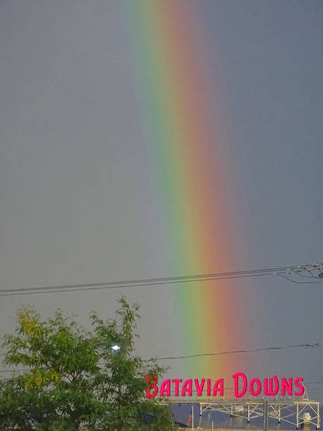
Photo from yesterday evening by Jim Schmitt.

Photo from yesterday evening by Jim Schmitt.
A series of strong thunderstorms is passing through the area, reports the National Weather Service.
The storms may intensify and torrential rains are possible, which could cause localized flooding.
Winds in excess of 30 mph are expected.
Le Roy Fire is requested to the viaduct on West Main Street near Royal Drive for a report of flooding.
UPDATE 10:51 a.m.: Westbound traffic is blocked at Gilbert Street.
UPDATE 10:59 a.m.: A vehicle got stuck in the water. The occupant is out of the vehicle. Gilbert Street is flooded. There is also flooding at the fire hall.
UPDATE 11:51 a.m.: The flooding has cleared on West Main Street.
There is a hazardous weather outlook in effect for Genesee County.
The National Weather Service says showers and thunderstorms today will increase in number with a marginal risk for strong to severe thunderstorms by late afternoon. Damaging wind gusts is the primary threat, with isolated large hail also possible.
Because of this outlook, tonight's free concert by the Batavia Concert Band at Centennial Park has been moved to Stuart Steiner Theatre at Genesee Community College. It will also feature a student alumni musical tribute to the late Batavia school band instructor Neil Hartwick.
At 1:11 p.m. today the National Weather Service in Buffalo issued a hazardous weather outlook for portions of Western New York, including Genesee County.
This afternoon and tonight, there will be a low probability of widespread hazardous weather. Starting late Thursday, scattered thunderstorms will approach, with a few capable of producing isolated damaging wind gusts and locally heavy rainfall.
The hazardous weather outlook continues through Tuesday.
A severe thunderstorm warning has been issued for all of Genesee County by the National Weather Service and it is in effect until 10:45 p.m.
The storm is moving east at 35 mph hour with wind gusts up to 60 mph. Damage to roofs, siding and trees possible.
The National Weather Service recommends moving to an interior room at the lowest floor of your building.
Large hail and damaging wind and continuous cloud-to-ground lightning spotted in this storm, along with torrential rainfall, and flash flooding is possible.
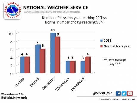
We're only in July and Batavia has already exceeded its "normal for a year" number of days of highs reaching 90 degrees, according to the National Weather Service.
Normal is six days of 90 degrees or higher. Batavia has reached that mark seven times so far.
Batavia could see temperatures as high as 90 degrees again on Sunday and Monday.
Press release:
Due to high energy demand caused by this week’s extreme heat and humidity, National Grid is asking Upstate New York customers to reduce unnecessary electricity usage for the remainder of the week. Electricity supply to the area is adequate, but continued heavy demand and high temperatures could pose a threat to network reliability.
The company recommends a few simple customer actions to help reduce demand on utility equipment and maintain system reliability. These small actions, combined with those of your neighbors, can make a big difference -- and they can help you better manage your energy bill.
Draw blinds, shades, drapes to prevent the sun from making your home too hot.
Slightly increase air conditioner settings, change the filter, use fans – The lower your air conditioner temperature, the more costly it is to operate. For example, a 75-degree setting will cost about 18 percent more than a 78-degree setting. Set the thermostat as high as comfort will permit. In addition, check your window air conditioner filter and replace or clean it if necessary. If your home has central air conditioning, check the condition of the furnace filter and replace it if dirty. Using fans instead of air conditioning also reduces energy usage.
Consider a programmable thermostat – You could save up to $180 annually by adjusting cooling temperatures when rooms are unoccupied.
Turn off lights when they are not needed.
Delay the use of hot water appliances like dishwashers and washing machines.
Unplug electronics – Even though your electronics, like televisions and computers, are turned off they may still draw electricity. Unplug any unnecessary electronics and chargers. In addition, using an advanced power strip on your entertainment system reduces phantom load energy use and can save you up to $60 annually.
Turn off your pool pump – Pool pumps are one of the largest consumers of household energy—second only to the air conditioning unit.
Reminder to Remain Diligent Regarding Heat Stress
National Grid also reminds customers that prolonged temperatures of 90°F or higher can lead to heat-related illnesses, especially for the elderly, young children and those with chronic illnesses. More information on heat stress can be found here.
A severe thunderstorm watch is in effect until 11 p.m. in Genesee County, and other portions of Western New York, according to the National Weather Service.
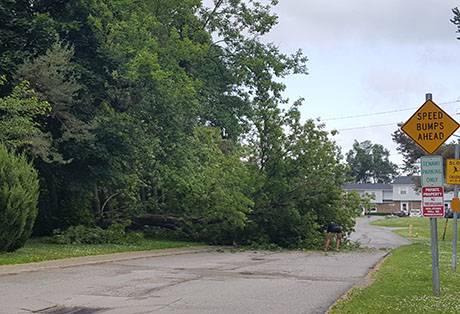
Reader John Michaels submitted this photo of a tree down at the Terrace Apartments.

Jess DiSalvo shared this picture taken at 5:40 a.m. of a rainbow over the Willow Group building on Clinton Street, Batavia.
A hazardous weather outlook is in effect for Western and North Central New York, which includes Genesee County, today and tonight.
Scattered thunderstorms will develop this afternoon and evening. Some of the storms will produce wind gusts.
Storms may also produce locally heavy rain with a small risk for flooding.
Also, scattered thunderstorms will develop Friday afternoon and evening, with some of the storms possibly producing locally heavy rain with a small risk for flooding.

Dayne Burroughs sent in this photo of some pretty ominous looking clouds gathering over Batavia just before a bit of heavy rain hit this morning.
A severe thunderstorm warning was issued at 4:10 p.m. by The National Weather Service office in Buffalo.
It is in effect until 4:45 p.m.
At 4:09 p.m. a severe thunderstorm was located over Batavia moving northeast at 75 mph. Wind gusts of up to 70 mph are a hazard. Up to three-quarters of an inch of hail are possible.
The weather service says: Expect considerable tree damage. Damage is likely to mobile homes, roofs, and outbuildings.
This area of impact includes the following highways: Interstate 390 between exits 11 and 12; and Interstate 90 between exits 48 and 46.
For your protection move to an interior room on the lowest floor of a building.
Also, a high wind warning is in effect until 10 p.m.
The air quality index for today is expected to exceed 100 for ozone so the DEC has issued a health advisory from 11 a.m. to 11 p.m.
Press release:
The air quality index...or AQI...was created as an easy way to correlate levels of different pollutants to one scale. The higher the AQI value, the greater the health concern.
When pollution levels are elevated the New York State Department of Health recommends that individuals consider limiting strenuous outdoor physical activity to reduce the risk of adverse health effects.
People who may be especially sensitive to the effects of elevated levels of pollutants include the very young and those with pre-existing respiratory problems such as asthma or heart disease.
Those with symptoms should consider consulting their personal physician.
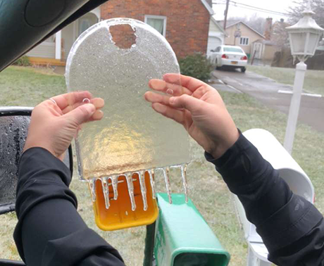
Alyssa Wolford, of Colonial Boulevard in Batavia, submitted this photo of the perfect sheet of ice molded by her mailbox cover.
Sheriff William Sheron has issued a travel advisory for all of Genesee County because of current and forecasted weather conditions consisting of high winds and icy roads with possibly downed power lines and trees over the next 24 hours.
With as much as half an inch of ice accumulation in the storm the National Weather Service says is heading our way, County Highway Superintendent Tim Hens is recommending local residents treat this as a significant weather event and "stay put" for the night.
"Most of the area will be getting about half an inch of ice, which will be heavy enough to bring down trees and power lines," Hens said. "Combined with a strong northeast wind, which is opposite of our normal prevailing wind, there is likely to be major tree damage and sustained power outages.
"There is likely only a few hours left to gather last-minute supplies," he added. "After that, I would recommend staying put."
Unnecessary travel, he said, will only make matters worse for highway departments, emergency vehicles an utility crews.
He advises that those running generators use safe fueling and operating methods.
"Do not run a generator indoors under any circumstances," he said.
National Grid also sent out this advisory:
In preparation for strong winds, freezing rain and ice accumulation across much of Upstate New York over the next 24 hours, National Grid has more than 2,000 line, service and tree workers on alert, including additional support from the company’s New England workforce and from neighboring New York utilities.
Crews are being deployed across upstate as needed, particularly in areas where the weather is expected to be the most severe. We urge customers to be prepared and remain safe.
Safety Tips:
Stay Connected
An ice storm is forecast for today starting at 2 p.m. with significant icing and gusty winds expected.
The ice storm warning is in effect until 2 p.m., Sunday.
Power outages and tree damage are likely, according to the National Weather Service, due to the wind and ice.
Travel will be difficult at times. Drivers should expect ice-covered surfaces and be on the lookout for downed tree limbs and power lines.
A spokesman for National Grid says there are still about 800 customers in Genesee County without power.
The areas with the most customers without power are Darien, 165, Batavia, 104, and Oakfield, 90.
The ETA for restoration is 10 o'clock tonight for all of Genesee County.
Copyright © 2008-2022 The Batavian. All Rights Reserved. Privacy Policy | Terms of Service
![]()