Photos: Rainbows in Batavia and Darien
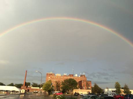
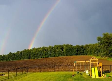
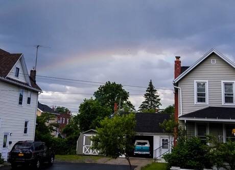
Brandi Kaplun sent in this picture of a rainbow over St. Jerome's in Batavia and a reader submitted the rainbow picture below from Darien.


Brandi Kaplun sent in this picture of a rainbow over St. Jerome's in Batavia and a reader submitted the rainbow picture below from Darien.

Photo submitted by Rachel Wommack.

Photo submitted by Alexandria Almeter.
A thunderstorm with 60-mph wind gusts is moving toward Genesee County at 45 mph and is expected to hit Batavia, Pembroke, Byron, Oakfield, Stafford, Alabama, Corfu and Elba.
The storm is currently over Clarence.
A severe thunderstorm warning has been issued by the National Weather Service.
The weather service says to expect damage to trees and powerlines.
The weather service urges people to seek protection in an interior room on the lowest floor of building.
Hail is also predicted.
The National Weather Service has issued a severe thunderstorm warning until 6:15 p.m. for Northwestern Genesee County.
At 5:29 p.m., a severe thunderstorm was located near Lockport, moving north at 15 mph.
Hazard: 60-mph wind gusts and quarter-size hail. Minor damage to vehicles is possible. Expect wind damage to trees and power lines.
For your protection move to an interior room on the lowest floor of a building.
A severe thunderstorm warning is in effect until 4:45 p.m. with wind gusts up to 60 mph and quarter size hail through parts of the county.
The storm is coming in from the southwest and will mostly hit the southern part of the county, according to the National Weather Service.
Minor damage is possible along with localized power outages.
There is an apparently unrelated power outage now in the Narramore Drive area. Some 100 customers are without power. Power is expected to be restored by 5:30 p.m.
UPDATE 4:18 p.m.: Flash flood warning in effect until 7:15 p.m.
A strong thunderstorm is blowing in from Canada and is expected to hit Genesee County this afternoon, according to the National Weather Service.
The storm system is located along a line extending 12 miles and is moving east at 55 mph.
Winds in excess of 40 mph are possible.
The storm system may gain in intensity.
UPDATE 12:27 p.m.: A severe thunderstorm warning has been issued.

Frank Capuano sent in the sunset picture and the rainbow picture was submitted by a reader.

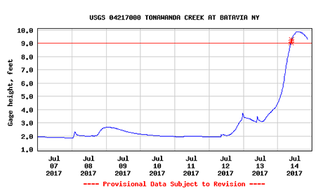
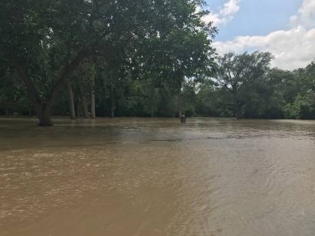
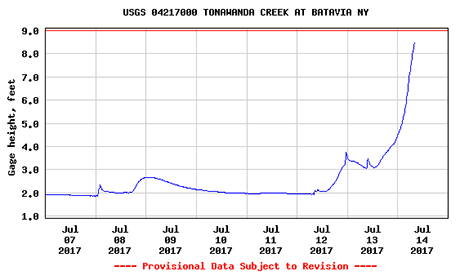
The water level on the Tonawanda Creek, as measured by the station behind the Genesee County Courthouse, peaked at just under 10 feet at about 8 p.m. and started to recede by 9 p.m., according to measurements captured by the USGS.
A flood alert remains in effect until Saturday morning.
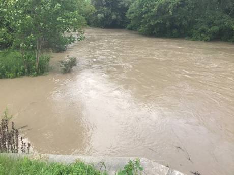
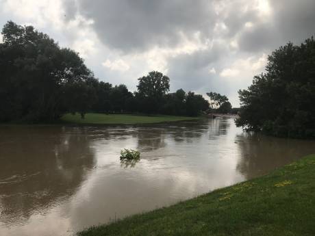
This photo of the nearly cresting Tonawanda Creek was taken about 20 minutes ago on Law Street by Howard from his cell phone.
The creek has been rising all day. The National Weather Service predicted earlier today that the Tonawanda would crest at 9.4 feet this afternnoon. Flood stage is considered to be 9 feet.
Tom Lichtenthal, assistant engineer for Town of Batavia, was also out at the Law Street bridge and reported that the water level now is 9.85 feet and it is expected to crest within the hour at 10.4 feet. Afterward, the waters will start to recede.
He said no major flooding problems are expected.
But he said engineers are concerned about a large tree trunk that is floating, but lodged in the creek. They are concerned that it could wedge free and float downstream to where the River Street Bridge project is underway.
A natural gas main under the bridge has been lowered by three feet to accommodate summer construction, when rains this heavy are not typical. There's some worry that large floating debris -- like a big tree trunk -- could strike and damage the gas line. So a crew from National Fuel is on scene now, working to raise the gas line to where it normally would be, says Lichtenthal.
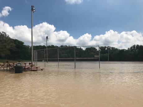
Impacted areas of flooding also include Kibbe Park and Walnut Street. Below are photos taken a few minutes ago at Kibbe Park.
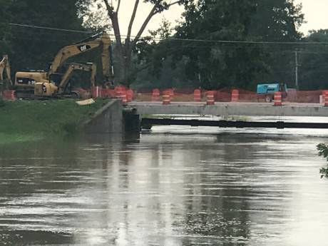
Three more pictures added -- River Street Bridge area and behind the courthouse.
At 9 a.m., the water level of the Tonawanda Creek, measured behind the courthouse, was 8.5 feet and rising, according to the National Weather Service.
Flood stage is 9 feet.
The creek is expected to crest at 9.4 feet this afternoon.
Impacted areas include Kibbe Park, Law Street and Walnut Street.
Also, expect flooding in the rural areas of Alexander and the Alabama Swamps.
The City of Batavia is warning of flooding along the Tonawanda Creek in the areas of Law Street, Walnut Street and Kibbe Park.
The Tonawanda is expected to crest at 9.7 feet, which is above flood stage levels.
Residents in the affected areas are asked to keep vigilant and take precautions to minimize property loss.
Flooding is reported on Cedar Street and on Route 20 in Alexander.
UPDATE 10:46 a.m.: All available manpower to Bethany Fire Hall for at least two cellar pump details.
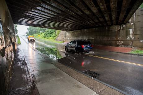
UPDATE 10:53 a.m. (By Billie): Le Roy firefighters are called to their hall for cellar pump detail. Route 5 under the railroad overpass in Le Roy is flooded. Le Roy Village highway department is notified. Flooding is reaching the second lane of the roadway at Route 19 and Hilltop.
UPDATE 11:12 a.m.: Photo added. A city worker said the flood waters under the train overpass on Cedar Street was higher before I got there. Even in the time between taking this picture and walking back to my car, the waters completely drained away. However, because of the potential for more heavy rain and more flooding, city workers put up barriers just to encourage people to slow down. City crews will continue to monitor the situation. Flooding is reported in Le Roy at Wolcott and Munson.
UPDATE 11:25 a.m.: There's a report of Warner Road in Le Roy being washed out.
UPDATE 11:32 a.m.: A black SUV is stuck at the "Route 238 viaduct." Help is on the way.
UPDATE 11:36 a.m.: An occupied car is stuck on Attica Street under a bridge in Alexander. Alexander Fire Department is responding along with a deputy.
UPDATE 11:49 a.m.: The car on Attica Road is out of the water and its female driver safe.
UPDATE 12:18 p.m.: A power line is down, lying in standing water on Bartoff Road in Stafford.
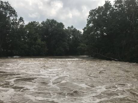
A flash flood warning has been issued for Western New York and it will be in effect until 1:45 p.m.
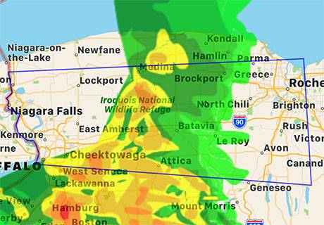
At 9:46 a.m., Doppler Radar detected thunderstorms producing heavy rain across the region.
A Special Weather Statement was issued a few minutes ago by the National Weather Service stating: "An area of strong thunderstorms will bring torrential rains to Northern Wyoming and Southern Genesee counties.
"Strong thunderstorms were clustered near Attica, or eight miles south of Batavia, moving east at 15 mph.
"These storms will bring very heavy rainfall to Attica and nearby locations with more than an inch of rain possible in an hour or less. Locations impacted include... Darien Lakes State Park, Le Roy, Bennington, Attica, Pavilion, Stafford, Covington, Alexander, Wyoming and East Bethany. This includes Interstate 90 near exit 47. Torrential rainfall is also occurring with this storm, and may cause localized flooding. Do not drive your vehicle through flooded roadways."
These conditions are expected until 2 p.m.
A hazardous weather outlook was issued today for portions of Western New York, including Genesee County, by the National Weather Service.
It says "An anomalously cold upper level trough crossing the region combined with warm lake temperatures will result in the development of lake effect rains tonight and into Tuesday, potentially resulting in localized flooding, particularly across low-lying flood-prone areas."

Top two photos are by Dan Kemp in Le Roy. Bottom photo by Frank Capuano in Batavia.
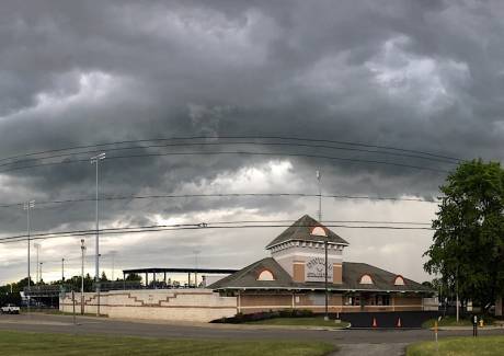
A reader sent in this picture from this afternoon suggesting the cloud looked pretty ominous with a ball game scheduled.
The Muckdogs did get the game underway, but it was later suspended and will be resumed on Sunday.
The Department of Environmental Conservation has issued an air quality alert for today, which is in effect until 10 p.m.
Air quality levels in outdoor air are predicted to be greater than an Air Quality Index value of 100 for the pollutant of ozone.
When pollution levels are elevated, the Department of Health recommends that individuals consider limiting strenuous outdoor physical activity to reduce the risk of adverse health effects. People who are especially at risk are those with pre-existing respiratory problems such as asthma and heart disease.

A severe thunderstorm is moving east, spreading across Western New York at 60 mph, the National Weather Service reports.
Wind gusts could reach 70 mph.
The weather service warns to expect considerable tree damage, and damage likely to mobile homes, roofs, and outbuildings.
Copyright © 2008-2022 The Batavian. All Rights Reserved. Privacy Policy | Terms of Service
![]()