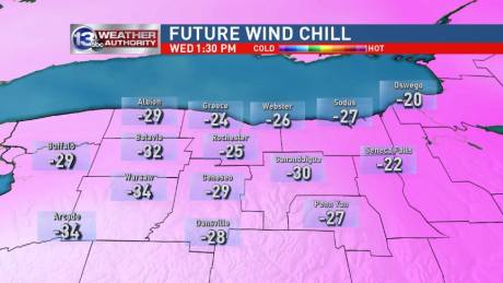
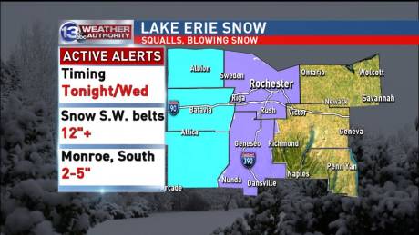
Stories from

Travel advisory still in effect, some closings reported

By Howard B. Owens

While a travel ban related to yesterday's blizzard-like conditions was lifted last night, this morning a travel advisory remains in effect and is expected to remain in place until 7 p.m.

A winter storm warning is in place until 7 p.m. though the current forecast doesn't show much snow for Batavia today. That, of course, could change.

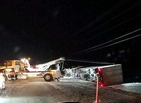
The photo above from a reader is of a truck rollover accident at Lewiston and South Main in Oakfield that occured around 10:30 p.m. The road is still closed but should reopen soon. The truck was carrying 80,000 pounds of blueberries. Complicating the effort to get it up right were the powerlines overhead. National Grid installed a new utility pole at that location overnight.

Updates on closings (for our prior post on closings, click here):

  • The Richmond Memorial Library will remain closed today.
  • WW at First United Methodist Church on Lewiston Road, Batavia is cancelled.
  • Pembroke Diagnostics -- 860 Main St., Corfu
  • Cardiac Rehab --  215 Summit St., Batavia
  • Le Roy Lab Services -- 3 Tountas Ave., Le Roy (Le Roy Primary Care remains open)
  • Town Hall in Darien is reopening today, but delayed by two hours. UPDATE: Town Hall closing at noon.
  • Classic Optical -- 44 Batavia City Centre, Batavia
  • The Divine Tree -- 19 Main St., Le Roy
  • Chassix is open and employees are asked to report for work.
  • UMMC Wound Care & Hyperbaric Medicine Center is closed.
  • High Voltage Tattoo & Piercing -- Closed today
  • Celebrate Recovery Meeting (at Northgate Free Methodist Church) for today, Jan. 31, is cancelled.

Send closings and cancelations to howard@thebataivan.com.

UPDATE 9:01 a.m.: We just spoke with Tim Yaeger, emergency management coordinator. He said the forecasters with the National Weather Service say they expect a lake effect snow band that is currently south of Genesee County to shift north sometime this morning. The band should stay south of the Thruway. This could mean more snow and wind for Batavia, and if the shift does occur, certainly for the southwestern part of the county. He said, "they used words like two-thirds of the county" could be hit by the band. "It's sunny now but we don't want anybody to get lulled into the idea that the storm is past," Yaeger said. The travel advisory and state of emergency remain in effect. He said county officials will reevaluate the situtation around noon.

UPDATE 9:35 p.m.: There's a report of drivers stuck at the Flying J getting agitated. Drivers are reportedly yelling at each other.

Sheriff lifts travel ban, travel advisory remains in effect

By Howard B. Owens

Press release:

The Genesee County Sheriff’s Office, in conjunction with the Genesee County Highway Department and Emergency Management Services, has issued a travel advisory for all of Genesee County. Motorists are encouraged to avoid all unnecessary travel due to the significant accumulation of snow combined with strong winds and sub-zero wind chill temperatures and zero visibility at times.

 Advisory is in effect from 9 p.m., Jan. 30, until further notice.

Sheriff Sheron reminds motorists that dark traffic signals that are not working are to be treated as a four-way stop. 

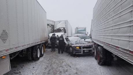
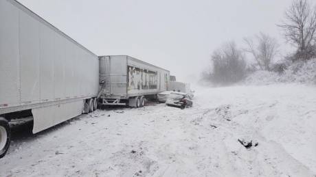
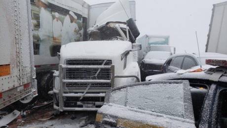
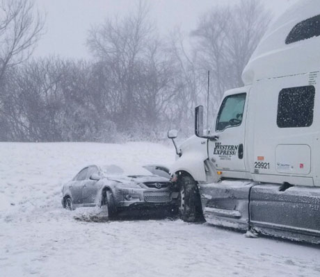
Photos: Multi-vehicle accident on Thruway during storm

By Howard B. Owens

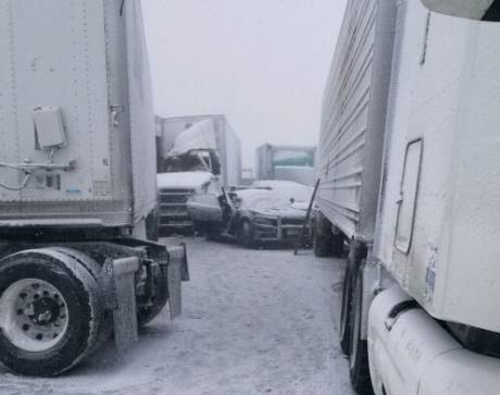
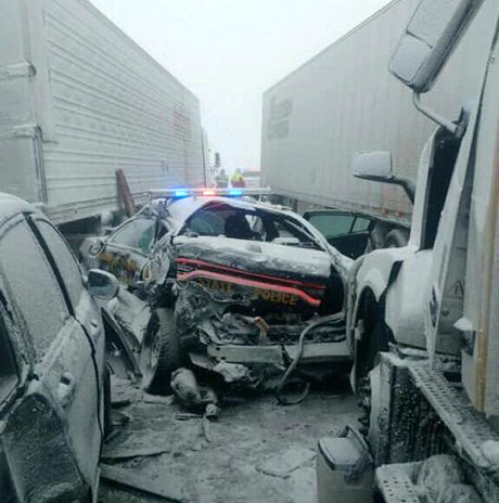
Twenty-one vehicles, including a State Police patrol vehicle, were involved in an accident that shutdown the Thruway through Le Roy this afternoon.

Injuries were reported but no details have been released.

Several people involved in the accident were transported by van to the Ontario Service Center where they were evaluated by Mercy medics and interviewed by Troopers.

Le Roy Fire, Town of Batavia Fire, with assistance from Caledonia and Monroe County, responded to the scene.

Top three photos released by State Police. Bottom two photos courtesy a reader.  If you have photos to share of the accident, send them to howard@thebatavian.com

(Initial Post)

UPDATE: Reader submitted photo added below.

Emergency coordinator explains need for state of emergency declaration in Genesee County

By Howard B. Owens

In order to enact a travel ban today, Bob Bausch, chairman of the Genesee County Legislature, signed a letter at 2 p.m. today declaring a state of emergency and that state of emergency is expected to be in place through tomorrow.

The travel ban could be lifted this evening, though, said Tim Yaeger, emergency management coordinator. 

"It was busy," Yaeger said. "It came in fairly quickly around noonish and started hitting very quickly. It has started to subside a little bit. Now, it's quieted down quite a bit. We're expecting the lake effect to move south but then reenter back into Genesee County tomorrow during the day."

Besides enabling the sheriff to declare a state of emergency, it gives county officials additional power, though Yaeger said there's no plans to, say, impose a curfew or ban alcohol sales. The county has also not used the state of emergency to ask for assistance from other counties or the state.

"We're continuing to monitor it at the point that we checked with our highway department superintendent and he's checking with the municipalities," Yaeger said. "But because the amount of snow at this point is manageable, we're going to continue to manage that. But that option is always open but at this point (no assistance) is needed."

Even as the snowfall slows down, the county remains on a ready footing. Each county fire department has personnel at their fire halls, City fire has extra personnel on duty, and the local law enforcement agencies have extra officers on patrol.

The Emergency Management Center is operating as a command center but Yaeger said it is at a "level 3" standard of operation.

"We are open and active and we're monitoring the weather and monitoring phone calls that are coming in the different situations so we have good situational awareness of what's going on in the county, so we can react to any of needs that may come up," Yaeger said.

The travel ban serves two primary purposes, Yaeger explained. It helps keep the public safe but it also helps keep first responders safe.

"The weather is our concern with the public out there," Yaeger said, "then the first responders trying to do their their work, to respond to emergencies, first to gain access there and then to be in these elements is extremely dangerous."

In this weather, it's especially important for first responders to get to stranded motorists quickly and safely.

"Because of the extreme cold you cannot be in those elements, or be in a vehicle and not be able to move and not have heat in your car," Yaeger said. "It is not safe at any point."

Photos: Reader photos from the storm

By Howard B. Owens

A reader from Byron shared this photo and the photo immediately below.

If you have a photo to share, send it to howard@thebatavian.com. You can also try to send video or upload your video to YouTube and we can share it.

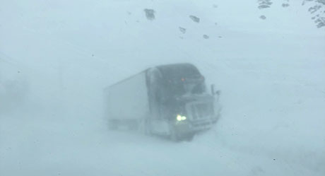
Andrea Brown said she took this photo about 12:30 p.m. on Route 77. "I was stuck along with other drivers for almost three hours until we all braved it to get home. I live in Attica so after I got past this, I sat in a gas station driveway along with a few others for another hour then finally made it home, getting here at about 4 p.m."

Photos: Batavia at start of today's storm

By Howard B. Owens

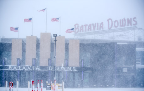
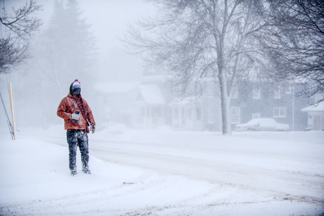
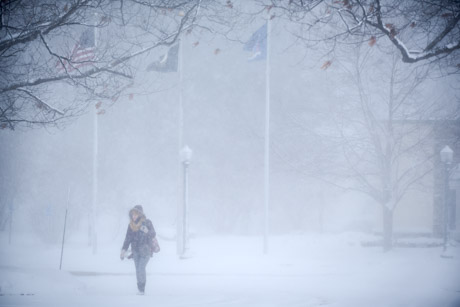
Photos in Batavia from about the one o'clock hour.

Top photo, Batavia Downs.

Main and Ellicott

Jackson Street

Parking lot at the courthouse.

Ellicott Avenue

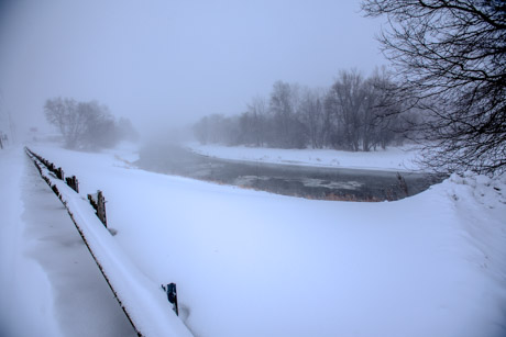
Tonawanda Creek off of West Main Street.

Centennial Park.

Centennial Park.

Genesee Community College

State and North

State Vets Home

Weather-related calls (UPDATED with Travel Ban for Genesee County)

By Howard B. Owens


All county fire crews requested to assemble in their fire halls and notify dispatched when assembled.

There is an accident with injuries at East Road and Route 20. Bethany Fire on scene.

Le Roy Fire and Town of Batavia Fire working a multi-vehicle accident on the Thruway (Updates will continue on the original post). 

Darien Fire and the Sheriff's Office is continuing to work an accident on Route 20 that is tying up traffic.

UPDATE 2:29 p.m.: Eastbound traffic is being diverted off the Thruway at Batavia. Expect an influx of traffic into Batavia.

UPDATE 2:33 p.m.: The Sheriff is issuing a travel ban. A news release coming shortly.

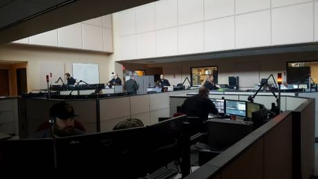
UPDATE 2:43 p.m.: Photos of dispatch center added.

UPDATE 2:46 p.m.: A tractor-trailer accident is reported at 6319 Main Road, Stafford. Powerlines are down. The road is blocked. An ambulance is requested to the scene. Stafford Fire dispatched.

UPDATE 2:49 p.m.: There are multiple reports of vehicles off the road at various locations. A trooper just informed dispatch he's going to a location on East Saile to check on an elderly couple.

UPDATE 2:50 p.m.: Travel ban release:

Effective immediately, a travel ban for Genesee County has been issued and will stay in effect until further notice.  Blowing and drifting snow have created poor visibility and unsafe/hazardous traveling conditions for motorists. 

A travel ban means no travel for anyone except emergency vehicles which includes police, ambulance, snow plows, etc.

Sheriff William Sheron stated, “For your safety, and the safety of the residents of Genesee County, please stay home or where you are until conditions improve.”

UPDATE 3:09 p.m.: For the latest closures, click here. Email closure announcements to howard@thebatavian.com.

UPDATE 3:13 p.m.: All Genesee County fire halls now fully staffed.

UPDATE 4:13 p.m.: From the National Weather Service:

At 3:56 p.m. EST, two bands of lake effect snow are producing snowfall rates
of up to 2 inches per hour along with visibilities near zero. 
Temperatures are below zero with wind chills near -25 degrees below zero.

...THIS IS A PARTICULARLY DANGEROUS SITUATION... 

Blinding snow and whiteout conditions are occurring. A casual drive or
trip outside can quickly lead to a life-threatening situation without
proper winter gear. Please heed all travel bans. 

UPDATE 4:25 p.m.: Weather photos post. Click here. (Also, if you have photos or video to share, email howard@thebatavian.com)

UPDATE 4:25 p.m.: Motor-vehicle accident, unknown injuries, Route 77 near McAlpine. Alabama fire dispatched and Mercy EMS. Also, Stafford just cleared its accident.

UPDATE 4:31 p.m.: An Indian Falls chief is on scene of the McAlpine accident. No injuries. Whiteout conditions.

UPDATE 5:53 p.m.: A blizzard warning is in effect until 1 a.m.:

Dangerously cold wind chills and blizzard conditions. Heavy lake effect snow expected. Wind chills as low as 25 below zero. Additional snow accumulations of 3 to 6 inches. Winds gusting as high as 35 mph. Winds gusting as high as 35 m.p.h.
 

UPDATE 7:57 p.m.: A state of emergency was declared for Genesee County at 2 p.m. Read about it in this story. Also, the Thruway has removed in both directions. A travel ban remains in effect but could be lifted this evening.

UPDATE 8:06 p.m.: Click here to view a video from the storm taken this afternoon.

UPDATE 8:09 p.m.: A rollover accident is reported at 5969 Ellicott Street Road, near Paul Road. Bethany Fire and Mercy EMS dispatched. Minor if any injuries.


Multi-vehicle accident reported on the Thruway in Le Roy

By Howard B. Owens

A multiple-vehicle accident is reported on the Thruway in Le Roy.

Le Roy Fire responding. Mutual aid requested from Town of Batavia.

A Le Roy chief asks a driver to bring a van in case shelter is needed for multiple people.

Two additional ambulances requested to the scene in case of multiple injuries.

UPDATE 2:17 p.m.: Caledonia requested to the scene.

UPDATE 2:22 p.m.: At least 15 vehicles involved, including tractor trailers. There are multiple injuries, including a truck driver with a head injury.

UPDATE 2:26 p.m.: At least six ambulances are required to the scene. Bergen requested to the scene.

UPDATE 2:29 p.m.: Eastbound traffic is being diverted off the Thruway at Batavia. Expect an influx of traffic into Batavia.

UPDATE 2:31 p.m.: A chief on scene wants to know ETA for an advanced life support ambulance. It is two or three minutes. The chief has given the ambulance driver instructions on how to get to the victims, who are at the front of the accident. "Don't worry. We'll make it happen," the driver tells the chief.

UPDATE  2:41 p.m.: Thruway being closed at Le Roy.

UPDATE 2:46 p.m.: A Caledonia crew requested to Le Roy fire hall to fill in.

UPDATE 3:03 p.m.: People involved in the accident who were not injured are being taken to the service center, where they can be kept warm and rest. Troopers will complete interviews with them there.

UPDATE 3:12 p.m.: Monroe County ambulances are being released from the scene.

UPDATE 3:25 p.m.: Multiple tractor-trailers can't up it up the hill on Route 20 east of Molasses Hill Road.

UPDATE 3:27 p.m.: The officer on scene wants to know if the hill can be salted. A snow plow is in route. "I've got trucks backed up as far as the eye can see down 20," the officer says.

UPDATE 3:50 p.m.: State Police, Troop T, are reporting 21 vehicles involved.

UPDATE 3:55 p.m.: A chief reports, "everyone is on the bus and the bus is on its way to the Ontario Service Center."

UPDATE 3:58 p.m.: All emergency units back in service. The Thruway is still being cleared of vehicles involved in the accident.

County election commission releases information on state's election law changes

By Howard B. Owens

Press release: 

The following information includes the changes to the political calendar that will affect candidates who wish to run for public office beginning this year. It also gives a summary of early voting. It is the Board of Elections' objective to give as much information to Genesee County residents so that implementing the new election laws will be as transparent and as seamless as possible.

  • Primary Election -- The primary election has been changed from mid-September to June 25, 2019. Going forward, the unified Primary date will now fall on the 4th Tuesday in June unless otherwise changed by the state legislature.
  • Petitions and Ballot Access -- The first day for signing designating petitions for public office is now Feb. 26, 2019, and the dates for filing petitions is April 1 – 4. These petition dates apply for the following designated Party lines based on the last Gubernatorial race; Democratic Party, Republican Party, Conservative Party, Working Families Party, Green Party, Libertarian Party, Independence Party and SAM Party.
  • Caucus Ballot Access -- For political Parties who are designated as a "caucus town" their nominating process will follow these dates -- the first day to hold a town caucus is Feb. 26 and the last to file certificates of nominations is July 25th.
  • Independent Petitions -- First day for signing Independent petitions is April 16, 2019. Dates for filing Independent petitions is May 21- 28.
  • Early Voting -- Early voting will be applicable for this year’s general election (Nov. 5, 2019) but not the primary election on June 25, 2019. In subsequent years early voting will be applicable for the primary election. The new law states that each county will provide, beginning on the 10th day prior to the general election and ending on and including the second day prior to the election, early voting at a polling location(s) to be determined by the County Board of Elections. This will include 9 days of early voting, five 8-hour weekdays which will include twoevening hours, and two 5-hour weekends ending the Sunday prior to the election. When these polling locations are determined they will be publicized in local media and on our website. 

UPDATED: Winter storm has stayed west of Genesee County but that is starting to change, travel advisory still in effect

By Howard B. Owens

UPDATED at 2:26 p.m. -- in bold

So far much of Genesee County has avoided the winter storm pushing through Western New York but snowfall and wind started to intensify in the western part of the county within the past 10 minutes.

County Highway Superintendent Tim Hens said it was pretty quiet in the county overnight even though Akron in Erie County got 12 to 15 inches of snow.

"I think the amount of ice on Lake Erie is limiting the reach of the snow," Hens said.

Sheriff William Sheron said a travel ban is now in effect and he is monitoring the forecasts.

The travel ban states that emergency personnel are responding to numerous personal injury accidents and vehicles off the road, so in the interest of public safety, there is to be NO UNNECESSARY TRAVEL.

The wind pattern may have shifted a bit from what forecasters expected as well.

"That's all it takes around here is a little twist in the wind and it goes somewhere else," Hens said.

With the snow band shifting south and Darien, Pembroke, and Alabama seeing increased snowfall now, the southern half of the county could see more snow today. Batavia, Hens said, is still forecasted to receive 6 to 8 inches of snow.

Hens said you can pretty much divide the county into four quadrants when it comes to snowfall. If the storm is blowing in off of Lake Erie, everything west of Route 98 and south of the Thruway gets hit. If the storm comes in from Lake Ontario, there's more snow east of 98 and north of the Thruway.

Hens said he isn't expecting much snow in Bergen and Le Roy today.

"Unless the moisture level picks up and the band expands we may not see much snow," Hens said, adding, "I've been in Buffalo for 47 years off and on and it (snow patterns) still fascinates me."

Closings announced for the next three days

By Howard B. Owens

Send your closings to howard@thebatavian.com

  • Due to the predicted inclement weather, GCASA’s Batavia and Albion offices will be closed, Wednesday, Jan. 30th. Crisis Services will be available at 585-815-1800.
  • All afternoon and evening activities in Batavia City Schools are canceled today. Schools will be closed Wednesday and Thursday due to the storm.
  • Classic Optical - closed Wednesday & Thursday
  • Alexander Central School
  • Byron-Bergen Central School District
  • Elba Central School District
  • Notre Dame High School
  • Pavilion Central School District
  • Pembroke Central School District
  • The Richmond Memorial Library will close at 5 p.m. and will remain closed until the travel advisory is lifted for Genesee County.
  • The GriefShare meeting scheduled to take place at Northgate Free Methodist Church has been canceled
  • Northgate Free Methodist Church and Arbor House (South Campus) are closing and canceling all activities for the remainder of Tuesday 1/29/19, Wednesday 1/30/19 and Thursday 1/31/19.
  • The Salvation Army store on Jackson Street will be closed Wednesday; it may possibly be closed on Thursday.
  • Northside Deli will be open Wednesday and Thursday 9 a.m. - 6 p.m. 
  • YWCA
  • Le Roy Central School District closed Wednesday and Thursday.
  • Darien Town Hall is closed Wednesday.
  • LeRoy Urgent Care – 3 Tountas Ave., Le Roy Primary Care offices remain open)
  • Pembroke Diagnostics - 860 Main St., Corfu
  • Alberty Drugs - Closing at 2 p.m. today
  • Valle Jewelers - Closing at 2 p.m. today
  • Benny's Barber - Closed for the remainder of the day
  • Scopano's Lanes in Oakfield -- County Line Stone League scheduled for tonight is cancelled.
  • Red Osier - Closed this evening. Reopens tomorrow at 4 p.m.
  • Blue Pearl - Classes cancelled today and tomorrow.
  • The Yngodess Shop
  • Tonawanda Valley Federal Credit Union closes at 2 p.m. Wednesday Jan. 30.
  • Le Roy Federal Credit Union closed at 1:30 p.m. Wednesday.
  • Foxprowl Collectables on Ellicott Street is closed Wednesday.
  • UMMC Cardiac Rehab at 215 Summit St. in Batavia will be closed Wednesday afternoon and tomorrow (Jan. 31).
  • Chassix Automotive -- Closed Wednesday for 2nd and 3rd shift.
  • UMMC practices and Urgent Care will be closing early Wednesday (1/30). Hospital and Emergency Department remain open 24/7. Call 585.343.6030 with questions.
  • Genesee County Animal Shelter will be closed for public visiting hours Wednesday. Animal Control officers will remain on duty and can be contacted at 343-6410.
  • Town, City and State courts closed at 2 p.m. Wednesday.
  • Applebee's restaurant in Batavia will be closed Wedensday evening (Jan. 30)
  • Batavia City Hall closed Wednesday at 2:30 p.m. due to weather.
  • Hardcor Audio
  • Art Ah La Carte is closed and will be closed on Thursday, Jan. 31.
  • Trash-Away customers whose normal pickup day is Thursday: Trash collection Jan. 31 is cancelled and will resume next week.
  • The Divine Tree - Closed Thursday

Travel advisory in effect for Genesee County

By Howard B. Owens

Press release:

In anticipation of the impending major snow/wind storm, the Genesee County Sheriff’s Office, in conjunction with the Genesee County Highway Department and Emergency Management Services, has issued a travel advisory for all of Genesee County.

Motorists are encouraged to avoid all unnecessary travel due to the expected significant accumulation of snow combined with strong winds and sub-zero wind chill temperatures.

These conditions will undoubtedly create white-out conditions and extremely dangerous travel for all motorists.  

This Advisory is in effect from today from 3 p.m. (Jan. 29) until further notice.

Sheriff William Sheron reminds motorists that dark traffic signals that are not working are to be treated as a four-way stop.

Heavy snowfall, high winds, bitter cold still in forecast for next 36 hours or so

By Howard B. Owens

The National Weather Service has revised its snowfall projections for the anticipated winter storm hitting Western New York this afternoon and expected to linger in the area until Thursday morning.

The weather service is calling for 8 to 15 inches of snow in some areas and winds as high as 40 mph with wind chills dropping to 30 below.

A winter storm warning is in effect. 

The forecasters at 13WHAM are predicting 6 to 10 inches of snow for Genesee County with Batavia's wind chill dipping to 36 degrees below zero.

The highest levels of snowfall in the county are expected to be west of Batavia.

The winter storm warning is in effect until 7 a.m., Thursday, with a wind chill warning in effect from 6 a.m. tomorrow through 6 p.m., Thursday.

The weather service cautions that travel during the worst of the storm could be impossible and that during the wind chill period frostbite is possible to exposed skin in less than 30 minutes.

Pets should be kept indoors to reduce their exposure to weather conditions.

Test weather post

By Howard B. Owens
The Batavian
broadstreet.zone(69076)

Tompkins reports record earnings

By Howard B. Owens

Press release:

Tompkins Financial Corporation reported record 2018 full year diluted earnings per share of $5.35, an increase of 56.0% compared to the $3.43 per share reported for the period ending December 31, 2017. For the fourth quarter of 2018, diluted earnings per share of $1.23 were up from the $0.16 per share reported in the same quarter last year.

As more fully disclosed in the Non-GAAP disclosure tables included in this press release, it is helpful to view comparisons to prior periods on an adjusted basis to exclude the impact of certain significant non-recurring items. Most notably, earnings per share and net income in the fourth quarter and year-to-date periods of 2017 were impacted by a one-time non-cash write-down of net deferred tax assets in the amount of $14.9 million as a result of the Tax Cuts and Jobs Act of 2017. On an adjusted basis, year-to-date diluted earnings per share for 2018 would have been $5.33, an increase of 20.6% over the adjusted diluted earnings per share of $4.42 reported for the year ending December 31, 2017. For the fourth quarter of 2018, adjusted diluted earnings per share of $1.23 reflecting an increase of 7.0% over the $1.15 adjusted diluted earnings per share reported in the same quarter last year. Refer to Non-GAAP Disclosure tables for additional details.

Due to changes in the Federal tax rates between periods, it is also helpful to view the current period and prior period earnings performance on a pre-tax basis. Income before tax expense was $104.2 million for the year ended December 31, 2018, and $23.8 million in the fourth quarter of 2018, reflecting an increase of 9.4% and 13.5%, respectively, over the same periods in 2017.

President and CEO, Stephen S. Romaine said “We are pleased to once again report record earnings for both the full year and quarterly periods. The results are especially rewarding in today’s environment of uncertain economic conditions. During the quarter, our net interest margin remained relatively stable as growth in average noninterest-bearing deposits helped soften the impact of rising market interest rates. Our diversified revenue sources have served us well in volatile markets, as fees from insurance, wealth management, and banking related services provide a revenue mix that is less dependent on interest rates. During 2018, each of these fee-based business lines reflected growth over the prior year."

SELECTED HIGHLIGHTS FOR YEAR AND FOURTH QUARTER:

  • Return on equity was 13.93% for the year ended December 31, 2018, compared to 9.09% for the full year ended December 31, 2017.
  • Net interest income for the fourth quarter of 2018 increased over the third quarter of 2018, which represents the 15th consecutive quarterly increase in net interest income.
  • Net interest income for the full year was up 5.2% over 2017.
  • Total loans of $4.8 billion at December 31, 2018, were up 3.5% over December 31, 2017, while total deposits of $4.9 billion were up 1.1% from the prior year-end.
  • Nonperforming assets remain near historically low levels and compare favorably to our industry peers, with nonperforming assets representing 0.42% of total assets at year-end 2018, compared to 0.38% at year-end 2017.

NET INTEREST INCOME

Net interest income of $53.2 million for the fourth quarter of 2018 was up 2.4% over the same period in 2017. For the full year, net interest income was $211.8 million, up $10.5 million, or 5.2% from the same period in 2017.

Growth in net interest income for the year ended December 31, 2018, was largely driven by $356.4 million of growth in average loans during the year, an increase of 8.1% over the prior period. Average deposits for the year ended December 31, 2018, increased $89.7 million, or 1.9% compared to the same period in 2017. Included in the growth of average deposits during 2018 was a $103.5 million increase in average noninterest-bearing deposits, up 8.1% from the prior year average.

Net interest margin for 2018 was 3.37%, down slightly from the 3.41% reported for 2017. The decline in margin during the year was largely due to increases in market interest rates, which has resulted in funding costs rising at a faster pace than asset yields.

NONINTEREST INCOME

Noninterest income represented 26.8% of total revenues in 2018, compared to 25.6% in 2017. For the full year, noninterest income of $77.4 million was up $8.2 million, or 11.9%, when compared to 2017. Noninterest income was $19.9 million for the fourth quarter of 2018 and was up $2.5 million or 14.7% compared to the same period in 2017. Fee income business related to investment services, service charges on deposit accounts, and card services income all contributed to the increase over the fourth quarter of 2017. Declines in the stock market during the fourth quarter of 2018 resulted in lower investment services fees tied to assets under management, though the impact was offset by higher than normal fees associated with trust and estate activities.

Other income in the fourth quarter of 2018 included $2.5 million related to the collection of fees and nonaccrual interest for a credit that was charged off in 2010. Other income for the full year included a $2.9 million gain on the sale of two properties. The sale of these properties was related to the move of the Company’s headquarters in the second quarter of 2018.

NONINTEREST EXPENSE

Noninterest expense was $47.2 million for the fourth quarter of 2018, up $0.9 million, or 2.0%, over the fourth quarter of 2017. For the full year of 2018, noninterest expense was $181.1 million, up $10.0 million, or 5.8%, from the same period in 2017. Noninterest expense increases for both the full year and fourth quarter of 2018 included normal annual increases in salaries and wages. The higher noninterest expense in 2018 included lease write-downs of $2.0 million in the second quarter and $514,000 in the third quarter related to leases on recently vacated space. Results for the quarter and full year periods also include an increase of $1.5 million and $2.8 million, respectively, in professional fees, primarily related to investments in strengthening the Company’s compliance and information security infrastructure.

INCOME TAX EXPENSE

The Company's effective tax rate was 20.9% for the year ended December 31, 2018, compared to 44.8% for the same period in 2017. The decrease is a direct result of the $14.9 million non-cash write-down of net deferred tax assets recorded in the fourth quarter of 2017, which was caused by the decline in the Federal statutory tax rate from 35% in 2017, to 21% in 2018 as a result of the Tax Cuts and Jobs Act of 2017.

ASSET QUALITY

Asset quality trends remained strong in the fourth quarter of 2018. Nonperforming assets represented 0.42% of total assets at December 31, 2018, compared to 0.38% at December 31, 2017. Nonperforming asset levels continue to compare favorably to the most recent Federal Reserve Board Peer Group Average1 of 0.61%.

Provision for loan and lease losses was $2.1 million for the fourth quarter of 2018, compared to $2.0 million for the fourth quarter of 2017. Net charge-offs for the fourth quarter of 2018 were $6,000 compared to net charge-offs of $281,000 in the fourth quarter of 2017.

The Company’s allowance for originated loan and lease losses totaled $43.3 million at December 31, 2018, and represented 0.95% of total originated loans and leases at December 31, 2018. At December 31, 2017, the allowance was $39.7 million and represented 0.91% of total originated loans and leases. Contributing to the $2.1 million increase in the allowance over the level reported at September 30, 2018, was an impairment reserve related to a single credit that was downgraded during the fourth quarter of 2018. The total allowance represented 163.25% of total nonperforming loans and leases at December 31, 2018, compared to 172.84% at December 31, 2017.

CAPITAL POSITION

Capital ratios remain well above the regulatory well capitalized minimums. The ratio of tangible common equity to tangible assets was 7.81% at December 31, 2018, improved from the 7.49% reported at September 30, 2018, and the 7.24% reported at December 31, 2017.
City reminds residents about snow removal procedures in advance of expected storm

By Howard B. Owens

Press release:

With the arrival of significant winter weather the past few weeks and next several days, the City of Batavia Department of Public Works would like to ask for the public’s cooperation as we all try and navigate these storms.

Private plowing contractors should be aware that plowing snow into the street or onto the sidewalk is not allowed and creates dangerous conditions for motorists and pedestrians.

Property owners are ultimately responsible for clearing sidewalks adjacent to their property. The City supplements sidewalk plowing as crews become available and as need dictates, however, this can only be completed after streets and municipal parking lots are plowed. School routes and main road sidewalks are then given priority.

We appreciate everyone’s efforts managing these snow events. 

State Police encourage drivers to avoid unnecessary travel during expected storm, offers safety tips

By Howard B. Owens

Press release:

The New York State Police is advising motorist to avoid any unnecessary driving during the winter storm that is forecast to bring a significant amount of snow and -25 degrees below zero temperatures across the Western New York Wednesday into Thursday evening.
 
Troopers will be out checking all major routes of travel to ensure that motorists are as safe as possible and working with local Emergency Operations Centers as needed. The State Police need your assistance to make this possible.

Motorists traveling in areas impacted by the snow are asked to leave with extra time to make a slow and careful drive to your destination. Take into consideration snow accumulation on the roads, the current snowfall rate, the wind, and visibility. Use your best judgment to determine if driving is prudent. 
 
Keep the following tips in mind:

  • Get the latest weather forecast before leaving with your local weather apps, monitor radio or TV stations.
  • Always clean your windows and mirrors FULLY of any snow and ice before driving.
  • Keep a full tank of gas.
  • Fluid levels are sufficient ( windshield washer fluid, anti-freeze).
  • Spare tire is sufficient and you have the jack and wheel wrench.
  • Use headlights at all times to increase your visibility to others. Remember, if your windshield wipers are in use due to weather, then your headlights must be on.
  • Drive prudently. If the conditions are adverse, you should decrease your speed accordingly.
  • Brake early.
  • Do NOT use cruise control. This decreases your reaction time to apply braking.
  • Look out for events farther down the road. Creating more time to react can make a difference.
  • Be aware of maintenance vehicles and emergency vehicles. Give them room to work.
  • If you do not absolutely have to go out on the roads, then don’t.

If you do go out, is your vehicle prepared?

  • Is your trunk supplied to help you to be safe in case you are stopped or stranded in an area without assistance readily available?
    • Gloves, blankets, warmers, tool kit, first-aid kit, nonperishable foods, water, working flashlight and batteries, cell phone charger, etc.
    • Shovel, ice scraper, de-icer, snow brush, rock salt or cat litter, tow chain or cable, jumper cables or battery charger, etc.

If you are involved in a collision or leave the roadway:
 
If you drive off the roadway and are stuck in a snow bank or ditch, stay in your vehicle and call 9-1-1. DO NOT exit your vehicle unless it is an absolute emergency. You put yourself at risk of being struck by another vehicle.
 
Roll your windows down a few inches or turn your vehicle off if you are stranded in snow for a period of time with your vehicle running. Covered mufflers can cause serious physical injury or death due to inhalation of carbon monoxide.
 
If you should become stranded on the Thruway or any roadway, know your location by being aware of your direction and mile post marker. This will help emergency personnel reach your location as quick as possible. 
 
Follow the New York State Police's Twitter page @nyspolice for up-to-the-minute information on road closures and weather alerts.
 
The Thruway Authority provides a wide variety of information for travelers including current traffic conditions, accidents, and lane closures. Visit www.thruway.ny.gov for more information. 
 
Slow down. Be prepared. Be safe.

Authentically Local