
weather

Winter weather advisory issued for Wednesday afternoon and evening

By Howard B. Owens

A winter weather advisory has been issued for Wednesday, from 1 to 10 p.m.

The National Weather Service says residents should expect snow, sleet and freezing rain. 

Less than an inch of snow is expected but with sleet and freezing rain, driving conditions could be hazardous.

Video: A snowy morning in Batavia

By Howard B. Owens
Video Sponsor
.pane-node-body img {background: none !important; border: 0 !important; margin: 0 !important; padding: unset !important; padding-left: 1px !important } broadstreet.zone(69076)


A mild but persistent snowstorm passed through the area overnight and into this morning. Snowfall is expected to taper off as we head into the afternoon. 

If you're viewing this on The Batavian app, click here to view the video on thebatavian.com.

Winter storm passing through Genesee County

By Howard B. Owens

winterfeb132019.jpg

There is a winter weather advisory in effect until 1 a.m. and weather radar indicates a winter storm is going to continue to pass right over Genesee Count for a while yet.

Lake effect snow of 1 to 3 inches is expected.

I just drove from Bergen to Batavia on Route 33, rarely going faster than 15 mph, often in zero-visibility circumstances. Roads are covered in snow and snow drifts are developing on some roadways.

There have been a number of minor accidents reported this evening.

Hazardous weather outlook for Genesee County, with slippery roads and surfaces, strong winds

By Billie Owens

A hazardous weather outlook is in effect for Genesee County tonight and a wind advisory is in effect from 1 a.m. through 10 p.m. on Wednesday.

The National Weather Service says winds will be from the west at 25 to 35 mph, with gusts up to 57 mph, making driving difficult and possibly resulting in minor property damage. Homeowners should secure personal property.

Mixed precipitation is forecast with additional snow and sleet accumulations of an inch or less. Expect snow and/or ice covered, slippery roads and reduced visibility.

National Grid ramping up staffing for wind storm, postpones planned outage for Batavia

By Howard B. Owens

As part of National Grid's preparations, the company is postponing a planned power outage in a portion of Batavia on Friday night and early Saturday morning, said spokesman David Bertola. Assuming the forecast holds, the outage, which will affect about 600 customers along the West Main Street corridor, will take place Feb. 15 and 16. Bertola said based on the forecast, National Grid's personnel will be deployed to storm coverage.

Press release:

With strong winds carrying gusts of up to 60 mph in the forecast for Western New York, National Grid is increasing its evening and overnight staffing and will have line crews report for duty earlier than normal tomorrow morning. The company is prepared for the upcoming weather and provides the following safety tips so customers can be prepared as well.

Electricity & Generator Safety

  • If a power outage occurs, customers can notify National Grid online to expedite restoration.
  • Never touch downed power lines; always assume they are carrying live electricity.
  • Downed lines should be immediately reported to National Grid at 1-800-867-5222 or to your local emergency response organization.
  • Generators used to supply power during an outage must be operated outdoors to prevent the buildup of deadly carbon monoxide. Before operating a generator, be sure to disconnect from National Grid’s system by shutting off the main breaker, located in the electric service panel. Failure to do this could endanger our crews and your neighbors.
  • Customers who depend on electrically powered life support equipment, such as a respirator, should register as a life support customer by calling National Grid at 1-800-642- 4272. (In a medical emergency, always dial 9-1-1.)
  • Keep a number of working flashlights and an extra supply of batteries in your home and be sure to charge all electronic devices.
  • Please drive carefully and use caution when driving near any crews working to restore power.
  • Be sure to check on elderly family members, neighbors and others who may need assistance during an outage.
  • Click here for a video of National Grid’s storm preparation and restoration process. 

High winds, freezing rain, flooding predicted for the area

By Howard B. Owens

There is a high-wind warning in effect from midnight tonight until 5 p.m., Friday.

Winds of 25 to 35 mph and gusts up to 60 mph are expected.

This could lead to downed trees and power outages. Travel for high-profile vehicles will be difficult.

The winter weather advisory for freezing rain remains in effect until noon today.

A flood watch is in effect through Friday.

UPDATE 10:51 a.m.: The freezing rain advisory has been extended to 3 p.m.

Photos: Ice at O-A and Indian Falls

By Howard B. Owens

img_20190206_210951207.jpg

Kris Kramer shared this picture from last night at Oakfield-Alabama High School of ice on the trees in the traffic circle after girls basketball last night.

Below, a picture from Chelsea DIbble of ice on a road sign in Indian Falls this morning.

indianfallsicesign.jpg

Photo: Icy branches at Upton Monument

By Howard B. Owens

iceuptonfeb52019.jpg

Icy covered trees throughout the region today, including behind the Upton Monument at Main and Ellicott in Batavia.

There's a weather advisory for tonight. Expect more ice through the morning.

Today's frozen rain creates icicles and ice, slippery surfaces and some frozen trees

By Billie Owens

Our very own marketing expert and graphic artist Lisa Ace, who lives in Batavia, sent us this photo of her backyard table this afternoon, festooned with a skirt of icicles.

With today's freezing rain, emergency responders were busy countywide with reports of frozen trees and wires down, and vehicles off the roadway. Fortunately, no serious injuries reported thus far.

Roads in the county getting slick from freezing rain, salt trucks being deployed

By Howard B. Owens

Reports are coming in of roads becoming slick and town and county salt trucks are being deployed throughout the county.

There is a weather advisory in effect for freezing rain with accumulations of four-tenths of an inch through the course of the day.

Power outages and tree damage from ice are possible. 

The National Weather Service warns travel could be difficult, especially during the evening commute.

UPDATE 10:20 a.m.: With some minor accidents reported earlier, a dispatcher reports there are multiple-accidents pending, including one on the Thruway (no injuries) with a car into the trees.

Photos: Ice jam on Black Creek in Byron

By Howard B. Owens

img_8621icejam.jpg

Nancy Clark shared these photos with us of an ice jam and ice overflow on Black Creek near Walkers Corner Road in Byron from this morning.

img_8618icejam.jpg

img_8622icejam.jpg

img_8625icejam.jpg

Closings for Friday, Feb. 1

By Howard B. Owens

Send closings to howard@thebatavian.com.

  • Batavia City Schools
  • St. Joe's Elementary School

Genesee County's travel advisory lifted, state of emergency canceled

By Howard B. Owens

Press release:

The Genesee County Sheriff’s Office, in conjunction with the Genesee County Highway Department and Emergency Management Services, has canceled the travel advisory for all of Genesee County as of 5 p.m., Jan. 31.

Motorists are encouraged to continue to drive with caution due to present blowing and drifting snow accumulation on roads and sub-zero wind chill temperatures.

Emergency Management Coordinator Tim Yaeger said the state of emergency has also been canceled.

We can confirm, there is a lot of blowing and drifting snow and low visbility at times on county grounds. Photos and video coming, hopefully later tonight.

Up to three inches of snow still possible in Genesee County before 7 p.m.

By Howard B. Owens

A winter storm warning and wind chill advisory remain in effect for Genesee County until 7 p.m., with the wind chill advisory in effect until 7 a.m., Friday.

Up to three inches of lake effect snow is possible today before 7 p.m.

A travel advisory and state of emergency remain in effect for Genesee County.

City fire chief reminds residents to be safe unthawing pipes

By Howard B. Owens

Press release:

With the arrival of frigid temperatures and a number of structure fires across the State recently resulting from homeowners utilizing open flames to thaw frozen pipes, City of Batavia Fire Chief Stefano Napolitano reminds all City residents to be mindful and take the following precautions.

OPEN FAUCETS
Prior to thawing a frozen pipe, open any faucet connected to the frozen pipe. Opening faucets with frozen pipes is important for two reasons. Frozen pipes will most likely burst from built-up pressure and not from the expanding ice. The opening of a faucet can relieve the pressure. Secondly, upon thawing frozen pipes, steam will be generated and can lead to increasing pressure and bursting if it is unable to escape out of the open faucet.

DO NOT USE OPEN FLAMES

Under no circumstances do not use open flames in any attempt to thaw pipes. The use of matches, a blowtorch or any other method with an open flame will compound the situation rather than solve it.

UTILIZE A GFCI OUTLET

Depending upon the thawing method used, please ensure that any device such as a hair dryer, heat gun or heat tape is connected to a GFCI (ground fault circuit interrupter) outlet. These outlets automatically monitor the current and are designed to protect people from electrical shock. The occurrence of electrocution is more significant during thawing situations due to the tools being electrical in nature and operating near potential water sources.

Chief Napolitano states that following these precautions and enlisting the services of a plumbing expert will safeguard your family and home from the devastation of a fire. He also offers all City residents to contact the City of Batavia Fire Department with any questions they may have regarding the safe thawing frozen pipes.

The phone number for City Fire Headquarters is 585-345-6375.

Travel advisory still in effect, some closings reported

By Howard B. Owens

truckrolloverjan302019.jpg

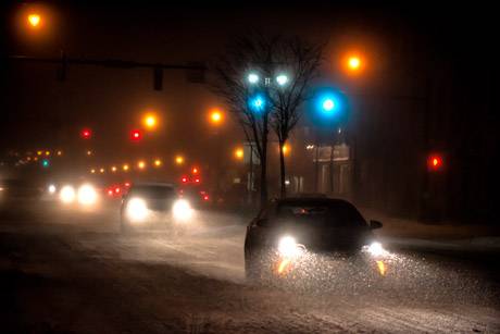
While a travel ban related to yesterday's blizzard-like conditions was lifted last night, this morning a travel advisory remains in effect and is expected to remain in place until 7 p.m.

A winter storm warning is in place until 7 p.m. though the current forecast doesn't show much snow for Batavia today. That, of course, could change.

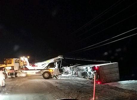
The photo above from a reader is of a truck rollover accident at Lewiston and South Main in Oakfield that occured around 10:30 p.m. The road is still closed but should reopen soon. The truck was carrying 80,000 pounds of blueberries. Complicating the effort to get it up right were the powerlines overhead. National Grid installed a new utility pole at that location overnight.

Updates on closings (for our prior post on closings, click here):

  • The Richmond Memorial Library will remain closed today.
  • WW at First United Methodist Church on Lewiston Road, Batavia is cancelled.
  • Pembroke Diagnostics -- 860 Main St., Corfu
  • Cardiac Rehab --  215 Summit St., Batavia
  • Le Roy Lab Services -- 3 Tountas Ave., Le Roy (Le Roy Primary Care remains open)
  • Town Hall in Darien is reopening today, but delayed by two hours. UPDATE: Town Hall closing at noon.
  • Classic Optical -- 44 Batavia City Centre, Batavia
  • The Divine Tree -- 19 Main St., Le Roy
  • Chassix is open and employees are asked to report for work.
  • UMMC Wound Care & Hyperbaric Medicine Center is closed.
  • High Voltage Tattoo & Piercing -- Closed today
  • Celebrate Recovery Meeting (at Northgate Free Methodist Church) for today, Jan. 31, is cancelled.

Send closings and cancelations to howard@thebataivan.com.

UPDATE 9:01 a.m.: We just spoke with Tim Yaeger, emergency management coordinator. He said the forecasters with the National Weather Service say they expect a lake effect snow band that is currently south of Genesee County to shift north sometime this morning. The band should stay south of the Thruway. This could mean more snow and wind for Batavia, and if the shift does occur, certainly for the southwestern part of the county. He said, "they used words like two-thirds of the county" could be hit by the band. "It's sunny now but we don't want anybody to get lulled into the idea that the storm is past," Yaeger said. The travel advisory and state of emergency remain in effect. He said county officials will reevaluate the situtation around noon.

UPDATE 9:35 p.m.: There's a report of drivers stuck at the Flying J getting agitated. Drivers are reportedly yelling at each other.

Sheriff lifts travel ban, travel advisory remains in effect

By Howard B. Owens

Press release:

The Genesee County Sheriff’s Office, in conjunction with the Genesee County Highway Department and Emergency Management Services, has issued a travel advisory for all of Genesee County. Motorists are encouraged to avoid all unnecessary travel due to the significant accumulation of snow combined with strong winds and sub-zero wind chill temperatures and zero visibility at times.

 Advisory is in effect from 9 p.m., Jan. 30, until further notice.

Sheriff Sheron reminds motorists that dark traffic signals that are not working are to be treated as a four-way stop. 

Authentically Local