Photo: 'Spring is Here'

Sarah Wessel, in Alexander, submitted this photo with a note that said, "Jasmine and Anabelle’s house. Spring is here."

Sarah Wessel, in Alexander, submitted this photo with a note that said, "Jasmine and Anabelle’s house. Spring is here."
A severe thunderstorm watch is in effect until 6 p.m.
A wind advisory is in effect from 2 until 11 p.m.
Winds of 20 to 30 mph expected with gusts of 50 mph.
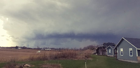
UPDATE 2:40 p.m.: Tristine Vanice submitted the photo above taken from her backyard off Lewiston Road, Oakfield, of the storm rolling in. Thunder and rain started in Batavia few minutes ago.
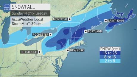
In case you didn't have enough to deal with right now, winter isn't done with you yet.
Accuweather is predicting a winter snowstorm, with up to eight inches of snow, hitting our region sometime Monday morning.
Weather.gov reports:
Sunday evening: Snow showers likely before 2 a.m., then rain and snow showers. Low around 30. East wind 8 to 13 mph becoming southeast after midnight. Chance of precipitation is 80 percent. New snow accumulation of less than a half inch possible.
Monday: Rain and snow showers before 9 a.m., then rain. High near 41. South wind 10 to 17 mph. Chance of precipitation is 100 percent. Little or no snow accumulation expected.
Press release:
National Grid is increasing staffing and closely monitoring Friday’s weather forecast (March 20), which calls for high winds, with gusts of up to 60 mph, across portions of Upstate New York. The company’s field force is at normal staffing levels and remains at the ready if the storm impacts service. Customers are encouraged to keep safety a priority with the following reminders:
Electricity & Generator Safety
If a power outage occurs, customers can notify National Grid online to expedite restoration.
Never touch downed power lines; always assume they are carrying live electricity. Downed power lines should immediately be reported to National Grid at 1-800-867-5222 or by calling 9-1-1.
Generators used to supply power during an outage must be operated outdoors to prevent the buildup of deadly carbon monoxide. Before operating a generator, be sure todisconnect from National Grid’s system by shutting off the main breaker, located in theelectric service panel. Failure to do this could endanger our crews and your neighbors.
Customers who depend on electrically powered life support equipment, such as a respirator, should register as a life support customer by calling National Grid at 1-800-642-4272. In a medical emergency, always dial 9-1-1.
Keep working flashlights and an extra supply of batteries in your home and be sure to charge all electronic devices before the storm.
Please use caution when driving near emergency responders and crews restoring power.
Be sure to check on elderly family members, neighbors and others who may need assistance during an outage.
Stay informed and connected
Information on National Grid’s pandemic preparedness and a customer Q&A can be found here.
Customers with active electricity accounts who text "REG" to 64743 can have personalized alerts sent to them via text, email or phone call when we detect an outage on their properties.
Customers also can text "OUT" to 64743 to report an outage.
For real-time power outage information, online outage reporting, and in-depth storm safety information, visit National Grid’s Outage Central website. Customers who create an online profile also can sign up for email alerts.
Visit our website.
From Accuweather:
Breezy, mild and very dry conditions, especially in areas that have lost the snowpack, will result in an elevated wildfire potential across portions of Western New York toward the Finger Lakes region.
The risk will be greatest in open and sufficiently dried out locations such as fields and less wooded areas. Any outside burning is strongly discouraged.
According to the NYS Department of Environmental Conservation, the statewide open burn ban is in effect March 16 through May 14.
It's currently 60, sunny and breezy.
Press release:
The Buffalo office of the National Weather Service will be conducting a SKYWARN spotter training seminar in Batavia, at the Genesee County Fire Training Center, 7690 State Street Road, at 7 p.m. on Monday, March 30.
The training session will last about two hours and there is no cost for the training.
SKYWARN is a national effort to save lives during severe weather emergencies with an expanding network of trained volunteer weather spotters.
SKYWARN spotters support their local community and government by providing reports of severe weather directly to the National Weather Service in Buffalo by phone using the NWS spotter hotline, by email, or social media. The services performed by SKYWARN spotters have saved many lives.
The National Weather Service has an array of modern technology for detecting severe thunderstorms. Included in these are Doppler radar, satellite, and lightning detection networks. However, the most important tool for observing thunderstorms is the trained eye of the storm spotter.
By providing observations, SKYWARN spotters assist National Weather Service staff in their warning decisions and enable the National Weather Service to fulfill its mission of protecting life and property. Storm spotters are, and always will be, an indispensable part of the severe local storm warning program.
The basic training session provides a brief overview of the National Weather Service organization and our responsibilities, severe weather safety, and basic severe weather meteorology including how thunderstorms, severe thunderstorms and tornadoes develop.
Anyone can become a severe weather spotter for the National Weather Service. SKYWARN training is free and open to the public. The training is being sponsored by the Genesee County Office of Emergency Management.
For further information, you can call the National Weather Service at (716) 565-0204, ext. 223.
More information about SKYWARN is available on the NWS Buffalo website at http://www.weather.gov/buf/Skywarn
Register online, call or email the Genesee County Fire Training Center:
National Weather Service on the Web:
Closures and cancellations for today:
Schools that have canceled classes:
Closures and cancellations:
Email closures and cancellations to howard@thebatavian.com

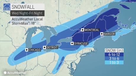
Heavy snow is expected tonight through tomorrow afternoon throughout Western New York.
A winter storm warning has been issued from 10 p.m. through 1 p.m. Thursday.
Snow accumulations of five to nine inches are expected with winds from 45 to 50 mph, which is likely to result in blowing and drifting snow.
The National Weather Service warns that travel will become difficult with very poor visibility and snow-covered roadways. The hazardous conditions will impact the Thursday morning commute. Gusty winds could bring down tree branches.
Graphic: Accuweather.
A Hazardous Weather Outlook was issued this afternoon by the National Weather Service office in Buffalo for portions of Western New York, including Genesee County. This afternoon and tonight south winds may gust in the 35 to 45 mph range, especially along the Lake Erie shore and across higher terrain.

A winter weather advisory is in effect for 12 hours, from 10 p.m. until 10 a.m. with three to five inches of snow expected in Genesee County, according to the National Weather Service
Residents can also expect very cold air to hit the region Thursday night through Friday night with wind chills dropping below zero.
Graphic: Accuweather
A winter weather advisory is in effect from 7 o'clock tonight until 1 p.m. Thursday, with a winter storm watch in effect from Thursday evening through late Friday night.
The advisory calls for mixed precipitation with snow accumulation of two to four inches and ice accumulation of a few hundredths of an inch.
For the winter storm watch, heavy snow is possible with as much as six inches falling on parts of Genesee County.
Travel could be difficult and perhaps hazardous at times.
Graphic: Accuweather.
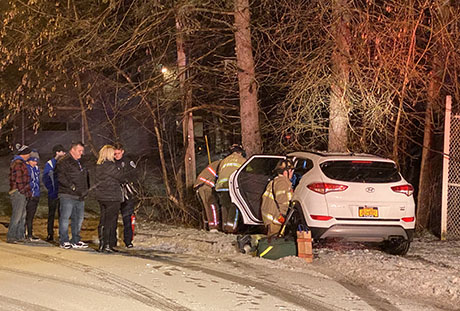
A light amount of heavy, wet snow is falling in Batavia and the roads are getting slick.
At about 8:35 p.m., a vehicle failed to negotiate a curve in Ganson Avenue and slid into a tree. City fire and Mercy EMS were called to the scene to evaluate a pregnant woman who was riding in the backseat.
Officer Mark Lawrence said City DPW has been notified of road conditions and are expected to start treating roadways.
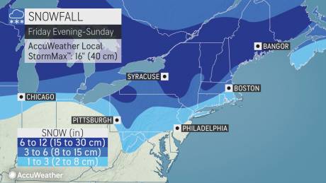
Genesee County could get as much as six inches of snow from a storm that is passing through the Northeast this weekend, according to a forecast by Accuweather.
The storm is expected to hit Western New York after 7 a.m., Saturday.
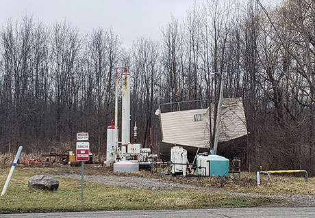
An outbuilding rests on its roof in Corfu (Town of Darien) off of Route 33 just east of the County line following Saturday night's windstorm.
Photo submitted by a Arielle McVay.
There are more than two dozen power outages reported in Genesee County following a night of strong winds that brought down trees and power lines and kept local fire crews responding to sparking and arcing lines throughout the night.
The largest outage is in the South Byron, Byron, and a bit into the Bergen area of the county with more than 800 National Grid customers without power. A work crew has just been assigned to that outage and power restoration is expected by 6 p.m.
There are six outages in the City of Batavia. The larges stretches along Ellicott Street from Jackson Street to Cedar Street and as far south as Jackson Primary School and north to about Florence Avenue. There are 547 customers without power in that outage. A crew has been assigned and power restoration is expected by 6 p.m.
There's an outage affecting 108 customers in the Naramore Drive area. A crew has not yet been assigned but power restoration expected by 6 p.m.
There are three other outages in the city affecting five customers are less.
There is an outage in the Town of Pembroke, west of Indian Falls, with 59 customers without power. No crew has been assigned. Power restoration is expected before 6 p.m.
There are two outages in Alabama. One affecting 16 customers the other 20. A crew has not been assigned. Power should be restored by 6 p.m.
On either side of Route 20 in Alexander and Bethany, along West Bethany Road and Molasses Hill Road, 58 customers are without power. No crew has been assigned and power restoration is expected by 6 p.m.
Residents in the area of Godfrey's pond, 42 customers, are without power. No crew assigned. Restoration by 6 p.m.
There's an area with 114 customers just west of Route 237 and mostly north of North Byron Road that is without power. No crew assigned. Restoration expected by 6 p.m.
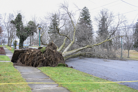
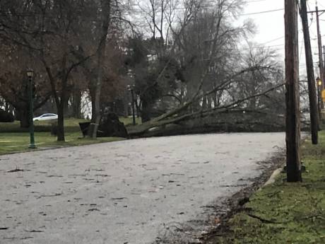
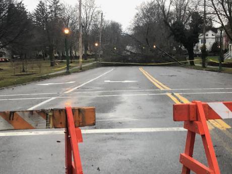
Photos: Top three photos by Philip Casper of a tree down on Ellicott Avenue.
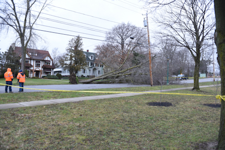
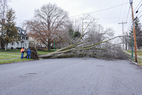
Below, reader-submitted photos. If you have weather-related photos to submit, email them to howard@thebatavian.com or text (585) 260-6970.
A telephone pole fell onto a house at 6281 Walker Corners Road in Byron. No word on injuries. Byron and South Byron fire departments are responding. "Residents are trapped," says a dispatcher. A Sheriff's deputy is heading there to check on residents.
Multiple power, phone and cable lines and signs and trees are down countywide and multiple alarms for fire and burglary have been called in due to strong winds during the early morning hours. Emergency responders have been very busy.
According to the National Weather Service, a powerful winter storm with snow, ice, heavy rain, severe thunderstorms and flash flooding hit much of the eastern United States Saturday and is expected to wind down today. Gusty winds are anticipated behind the storm which is why wind advisories are issued across a large portion of the eastern United States, including Genesee County.
UPDATE 6:47: "Sounds like (Byron and South Byron) fire's all set. Where do you want me to go next?" the deputy asks.

Jackson Briggs, son of Batavia Blue Devils football Coach Brennan Briggs, made his first snowman today, finishing it this morning in advance of the Buffalo Bills' playoff game today in Houston.
Photo submitted by Brennan Briggs.
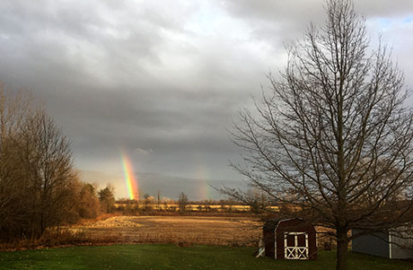
Caitlin Napper submitted this photo of a double rainbow taken today in Le Roy.
A potentially dangerous snow squall is moving through the region and is expected to hit Genesee County by 12:45 p.m., according to the the National Weather Service.
A weather warning has been issued.
The Weather Service warns of poor visibility, heavy and blowing snow, with wind gusts of 30 mph.
The warning is based on radar images.
The Weather Service warns of "dangerous life-threatening travel" during the squall.
Copyright © 2008-2022 The Batavian. All Rights Reserved. Privacy Policy | Terms of Service
![]()