
weather

Forecast unchanged for ice and snow in Genesee County

By Howard B. Owens

dangerousicestoremnov2019.jpg

A winter weather advisory remains in effect for Genesee County starting at 4 a.m. and continuing until 6 p.m. Sunday with snow and ice expected.

Travel conditions could be treacherous, the National Weather Service advises. 

From one to three inches of snow accumulation and two-tenths of ice accumulation are predicted.

The NWS advises travelers to plan accordingly.

Graphic: Courtesy Accuweather.

Winter weather advisory in effect Sunday, expect slippery road conditions

By Billie Owens

A winter weather advisory is in effect for Genesee County from 4 a.m. to 6 p.m. Sunday, according to the National Weather Service in Buffalo.

Mixed precipitation is expected, including total snow accumulations of one to two inches, and up to four inches across the northern Finger Lakes, with total ice accumulations of around 1/10th of an inch.

Plan on slippery road conditions. Periods of snow, sleet or freezing rain will result in slippery roads and limited visibilities. Slow down and use caution while driving.

Video: Pre-winter snowstorm in Batavia

By Howard B. Owens
Video Sponsor
.pane-node-body img {background: none !important; border: 0 !important; margin: 0 !important; padding: unset !important; padding-left: 1px !important } broadstreet.zone(69076)

At least six inches of snow expected tomorrow

By Howard B. Owens

Get ready, here it comes, maybe, the first significant snowfall of the season.

The National Weather Service has issued a winter storm watch for Monday morning through late Monday night.

Snow accumulations of 6 to 10 inches are possible.

The worst travel conditions, the period of the heaviest snowfall, is expected from late Monday afternoon through Monday night.

Photo: Tree in a cornfield on a snowy day

By Howard B. Owens

route33237treestaffordnv2019.jpg

We got a bit of snow today. In this photo, you can see the flakes cutting across the tree in a cornfield off of Route 33 near Route 237 in Batavia. We may get a little more snow tonight, with an anticipated low tonight of 28 degrees.

Overnight wind knocks out power at more than a dozen locations in Genesee County

By Howard B. Owens

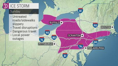
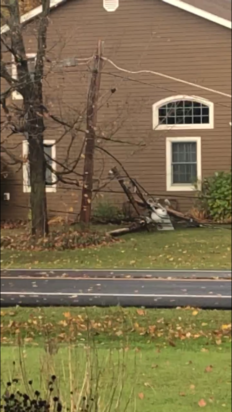
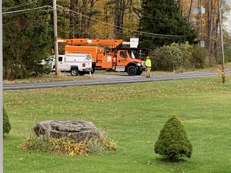
There are at least 16 power outages reported in Genesee County after strong winds swept through the region overnight and are expected to continue into the early afternoon.

The largest outage appears to be in Pavilion and Stafford, just northwest of Texaco Town, with 87 customers without power. A crew is assigned and power restoration is expected by 4:30 p.m.

An outage in Batavia and Elba, just west of Route 98 has 52 customers without power. A crew is assigned and power is expected to be restored by 4 p.m.

In East Oakfield, 31, one customers are without power and should have it back by 4 p.m.

In Alexander, east of the Village on Route 20, 31 customers are without power. Restoration is expected by 4 p.m.

In Alabama, just west of the Route 63/77 intersection, 23 customers are without power. No crew has been assigned but power should be restored by 4 p.m.

In Byron, near Route 237 and Route 262, 20 customers are without power. Power should be restored by 4 p.m.

There is one outage in the Village of Le Roy with 13 customers affected and restoration expected by 4 p.m.

In the City of Batavia, there are two outages, one on the Southside, one near Clinton Street, with fewer than five customers affected at each location and power should be restored by 4 p.m.

Heavy rain anticipated during trick-or-treat hours

By Howard B. Owens

The National Weather Service is forecasting heavy rain, about a half-inch, between 4:30 and 7 p.m. for Genesee County.

Those are prime trick-or-treat hours but at least two venues in Batavia are moving their Halloween-related events indoors.

There is an event, a fall festival, starting at 5 p.m. at City Church's St. Anthony's facility on Liberty Street and what was originally a "trunk-or-treat" event at Grace Baptist on Vine Street at 5:30 p.m.

As for the rain, expect flooding in low-lying areas. Motorists are urged to slow down during the storm. Brief gusty winds are expected around 7 p.m. before strong winds arrive before the morning.

Wind warning issued for tonight

By Howard B. Owens

Strong winds are expected to start tonight at 8 p.m. and a high wind warning and hazardous weather outlook statement has been issued by the National Weather Service for Genesee County and most of Western New York.

Winds of 40 mph with gusts of 60 to 65 mph are forecast.

The warning is effect until 1 p.m. tomorrow.

Damaging winds could bring down trees and power lines. Widespread power outages are expected. Travel will be difficult, especially for high-profile vehicles.

The weather service urges people to avoid being outside and around trees and branches. The statement urges residents to remain in the lower levels of homes and to avoid windows.

Hazardous weather outlook: high winds expected Thursday through Friday evening

By Billie Owens

A hazardous weather outlook was issued shortly after 3 p.m. today by the National Weather Service in Buffalo for portions of Western New York, including Genesee County and specifically the City of Batavia.

There's a high wind watch in effect from Thursday evening through Friday evening.

Southwest winds 30 to 40 mph are expected with gusts up to 60 mph possible.

Damaging winds could blow down trees and power lines. Given the wet antecedent conditions that will be in place, shallow rooted pines will be most vulnerable.

Widespread power outages will be possible. Travel could be difficult, especially for high profile vehicles.

Fasten loose objects or shelter objects in a safe location prior to the onset of winds.

Video: Hail in Bergen

By Howard B. Owens

Reader Brandan Smith submitted this video of hail falling in Bergen.

Batavia also got hit with some thunder and lightning and hail though there was no prior alert from the National Weather Service of a heavy storm passing through the area.

Photo: Sunset in Alabama

By Howard B. Owens

70182248_696890667467291_5411881001682993152_n.jpg

Rachael Anderson shared this picture from this evening of sunset in Alabama.

Hazardous weather outlook -- thunderstorms, damaging winds and hail, high afternoon temperatures

By Billie Owens

A hazardous weather outlook for Genesee County and portions of Western New York was issued this morning.

Thunderstorms are likely today. The storms could become quite strong during the midday and early afternoon with the greatest threat from the storms being localized damaging winds and hail.

Strong to severe thunderstorms will again be possible on Sunday with the risk for another round of localized damaging winds and hail.

Afternoon apparent temperatures Sunday through Tuesday may reach the lower 90s or higher. Keep in mind that heat advisories are issued when apparent temperatures reach at least 95 for two consecutive hours.

Strong thunderstorm with possible 40-mph winds could cause local flooding, frequent lighting expected

By Billie Owens

At 4:41 p.m., the National Weather Service issued a Special Weather Statement for Southwestern Genesee County and other portions of Western New York.

A strong thunderstorm was located a short time ago over Darien Lakes State Park, moving northeast at 25 mph. Winds in excess of 40 mph are possible with this storm.

Locations impacted include: Batavia, Darien Lakes State Park, Le Roy, Pembroke, Pavilion, Byron and Oakfield.

This includes the following highways: Interstate 390 near exit 10; Interstate 90 between exits 48A and 47.

If outdoors, consider seeking shelter inside a building. Torrential rainfall is also occurring with this storm, and may cause localized flooding. Do not drive your vehicle through flooded roadways.

Frequent cloud-to-ground lightning is occurring with this storm. Lightning can strike 10 miles away from a thunderstorm. Seek a safe shelter inside a building or vehicle.

This storm may intensify, so be certain to monitor local radio stations and available television stations for additional information and possible warnings from the National Weather Service.

Severe thunderstorm expected for Oakfield and Byron

By Howard B. Owens

Heaving, dangerous and damaging hail, along with strong winds, is expected by 2:30 p.m. in a storm sweeping across the northern part of Genesee County, according to the National Weather Service.

Oakfield and Byron are mentioned specifically in the warning.

The storm is moving at 35 mph an hour and could bring gusts of 70 p.m.

Hail the size of ping-pong balls is expected. This could injure people and animals that are outdoors as well as damage roofs, siding, windows, and vehicles. 

Cloud-to-ground lightning is also predicted.

The NWS recommends that people in the area move to an interior room of a building on the lowest floor possible.

Torrential rainfall is accompanying this line of storms. Flash flooding is possible.

UPDATE 2:30 p.m.: An severe thunderstorm watch has been issued for all of Genesee County, in effect until 10 p.m.

Heat advisory in effect from noon Friday through 6 p.m. Saturday

By Billie Owens

The National Weather Service this afternoon issued a heat advisory for noon Friday, July 19, through 6 p.m. Saturday, July 20. for portions of Western and North Central New York.

A few brief rounds of thunderstorms are also expected Friday through Sunday night. A few of these storms may be severe, with isolated damaging winds and torrential downpours.

Heat index values of up to 100 degrees are expected during the day Friday and Saturday. Overnight low temperatures in the upper 60s to low 70s with continued muggy conditions Friday night.

Prolonged exposure or any strenuous activity may lead to heat related illnesses that require immediate medical attention.

A Heat Advisory means that a period of hot temperatures is expected. The combination of hot temperatures and high humidity will combine to create a situation in which heat illnesses are possible.

Drink plenty of fluids; stay in an air-conditioned room; stay out of the sun; and check in on relatives and neighbors.

Take extra precautions if you work or spend time outside. When possible, reschedule strenuous activities to early morning or evening.

Know the signs and symptoms of heat exhaustion and heat stroke. Wear light weight and loose-fitting clothing when possible and drink plenty of water.

Authentically Local